How pilots keep you safe and comfortable during inclement weather
The weather plays a big part in how smooth your flight experience is. It has an effect on how bumpy it is and also how likely it is to depart and arrive on time. I already discussed how the earth's atmosphere and the wind can impact your journey — but those aren't the only things that can alter a flight.
Thunderstorms are probably the most dramatic weather phenomena going. They can turn day into night and dump more rain and hail in a few minutes than you might expect to see in a week. Whilst big thunderstorms are not that frequent in the UK, travel to the USA or the tropics and you'll see some really impressive examples.
How Thunderstorms Form
The king of weather phenomena, cumulonimbus clouds, referred to as 'CBs' in pilot chat, should never be underestimated. It's estimated that there are around 40,000 thunderstorms around the world in a given 24-hour period. They are synonymous with heavy rain, strong winds and severe turbulence.
Thunderstorms need three elements to form. A source of moisture to give them substance, a source of lift to help them grow and unstable air to continue that growth. As a result, when meteorologists see these three factors are present, they can quite easily predict that thunderstorms are likely.
Moisture
Clouds are just condensed water vapor that form around microscopic nuclei — anything solid that can act as a core, for example smoke or dust particles. For any cloud to form, there has to be a source of moisture. More often than not, this comes from the oceans.

However, the temperature of the water also plays a big part in how likely CBs are to form. Evaporation is more prevalent in warm water systems. As a result, more moisture is put into the atmosphere compared with areas of cold water.
Lift
Once there is moisture in the air, it needs a source of lift to allow it to climb and form a cloud. This lift comes from variations in the air density, which is affected by a number of elements.
During the day, the sun heats the surface of the earth. As the surface heats up, some of that heat is transferred into the air. However, this heating isn't uniform as some areas heat up quicker than others.
Take a tarmac carpark next to a grassy field. The carpark will heat much quicker than the grassy field, creating columns of air above them of different temperatures. As the cooler air over the grass is heavier, it sinks. As it sinks, it spills over into the area of the car park, pushing the warm air even high up.

These columns of moving cool and warm air are called thermals. Pilots know that if they pass over an area like a motorway or car park on the approach to land in the summer, they are likely to get extra lift. As they then cross over above the grass before the runway, they can experience a sink. A well trained crew will be aware of this possibility and will be prepared to act accordingly.
In the UK, there tends not to be the heat from the sun required to form thunderstorms in this way. Instead, they are more likely to occur as part of a frontal system. Fronts are the boundary between warm and cold air masses, and therefore, areas of different air density. The colder, more dense air lifts the warmer air ahead of it. If this air is moist, thunderstorms will form along the front.
Instability
Even if the air has a source of lift, unless it can keep growing, thunderstorms will not form. This is where instability comes in. If an object is pushed upwards and continues to rise, the air is considered to be unstable. It normally occurs when cold, dry air sits on top of warm, moist air.
When these conditions occur, if a mass of the warm, moist air is pushed upwards, it continues to climb. If you remember from earlier, as height increases, the air cools. When this mass of air starts to cool, some of the water vapor condenses to form the distinguishable thunderstorm clouds. As this vapor cools more, it falls as rain and sometimes hail.

Rain and Hail
Have you ever experienced one of those 'freak' showers in the summer? One of those where you're out in shorts and flip flops on a warm August day, only to suddenly find yourself being bombarded by pellets of ice from above? As you dash for cover, you see what looks like snow start to accumulate on the pavement. Before you know it, the hail as subsided and there's bright blue sky again.
"The weather can't make up its mind!" How often have you heard this phrase in situations like the above? In fact, this short-lived phenomenon is textbook thunderstorm activity. The weather is doing exactly as you'd expect for the conditions.
These storms. as described above, can form in as little as 30 minutes. As the water vapor inside the cloud rises and runs out of vertical energy, it cools in the colder temperatures aloft. As with anything in aviation, what goes up, must come down. This precipitation falls, creating the brief, but intense, showers you experience on the ground.
As the cloud is then blown along by the upper winds, the area over which the precipitation falls also moves. This results in the sudden appearance of blue sky once again. Not the weather unable to make up its mind, it's just doing what it does.
Heavy rain isn't much of a problem for aircraft in the air. During the design phase, the engines are tested to ensure that they can take the worst of what the weather can throw at them. The video below shows how tons of water and ice are forced into the engines and they continue to operate perfectly.
Where heavy rain can affect aircraft is on takeoff and landing. For every takeoff and landing, pilots carry out detailed calculations to determine if it is safe to do so. One factor in these calculations is the state of the runway — whether it is dry, wet or even covered in snow or ice.
If the runway is wet, the braking efficiency is degraded and the aircraft will take a longer distance to stop. As a result, pilots factor this into their landing distance calculation to ensure that the runway is long enough to stop safely for the given conditions.
It's the same on takeoff. Pilots need to know at what point they can no longer stop safely. A wet runway means that this decision point will be reached earlier in the takeoff run. By performing these calculations before the event, pilots don't have to react instinctively in the moment. They base their decisions on figures calculated at a time of low work load.
I'll be talking more about takeoff and landing performance in a future article.
Wind
Sitting in the departure lounge looking out the window, the first sign you'll probably get of an approaching thunderstorm is the sky darkening. As the thick storm cloud approaches, keep an eye on loose objects on the ground. You'll notice tarpaulins over baggage carts start to flap in the wind. Flags on buildings will be blowing much stronger than before. These gusts of wind are tell-tale signs of an approaching storm.
Gust fronts
You'll remember from the section above that when water vapor cools in a cloud, it falls as rain or hail. As it falls, it creates downdrafts of air that also head down to earth. When these downdrafts hit the surface, the have nowhere else to go but outwards. Think of pouring a glass of water onto the floor. As the water hits the ground, it splashes outwards. Keep pouring the water and the splashing isn't uniform. Sometimes it goes farther in one direction, other times not so far.
It's the same with the wind. As it hits the surface, it spreads out at different rates. It's this difference in speed that creates the gusts. As the CB cloud moves across the ground, these gust fronts push out ahead of the cloud, giving a good indication that a thunderstorm is imminent.
For pilots, this change in wind speed and direction can have a major effect on the flight. If you remember from my previous article, variations in the wind are what cause turbulence. Thunderstorms and the gust fronts associated with them are therefore taken very seriously by pilots and air traffic controllers.
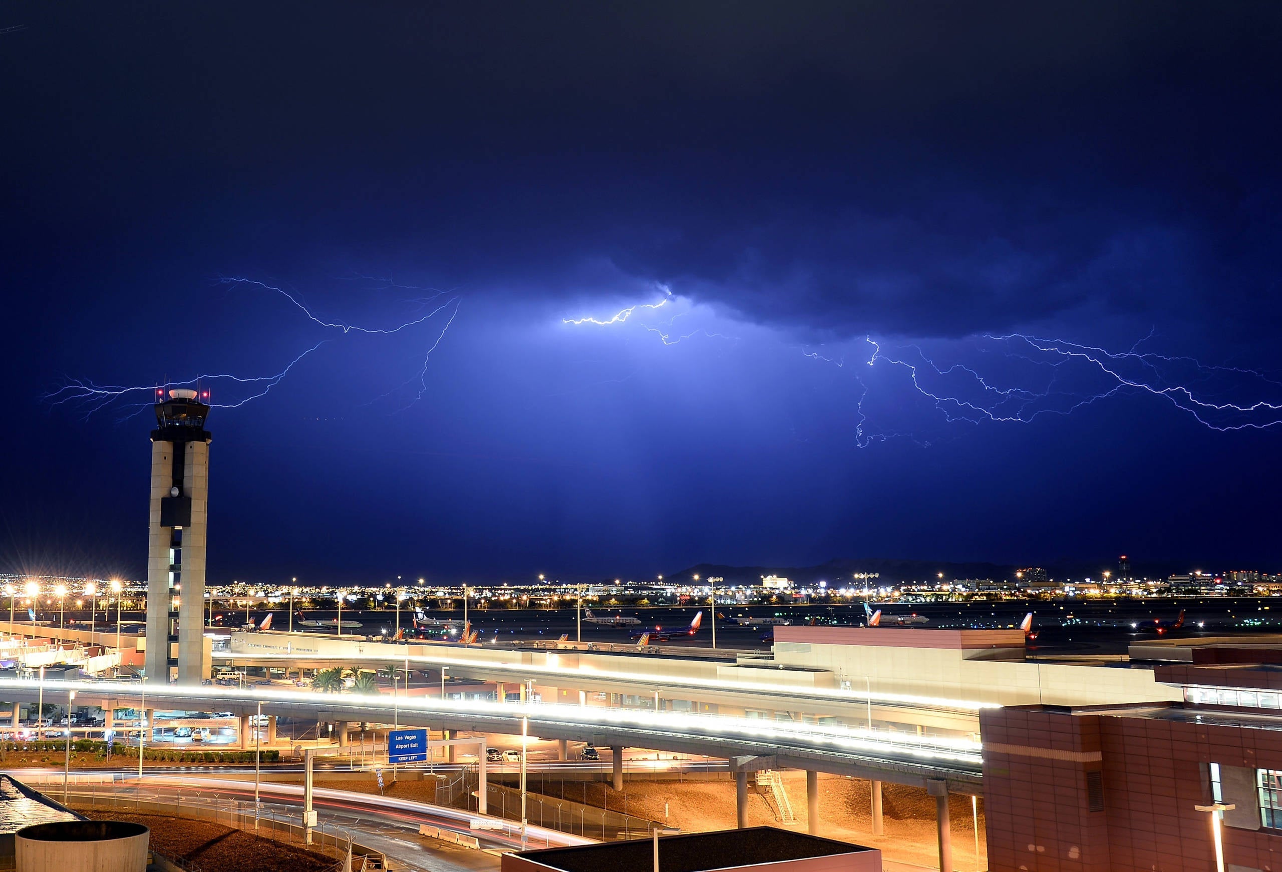
Lightning
The general public loves a good photo or video of an aircraft being struck by lightning. Inside the aircraft, you may experience a loud bang and even a flash — and if this happens, it certainly gets your attention. However, whilst it looks dramatic, strikes like this have little to no effect on the aircraft.
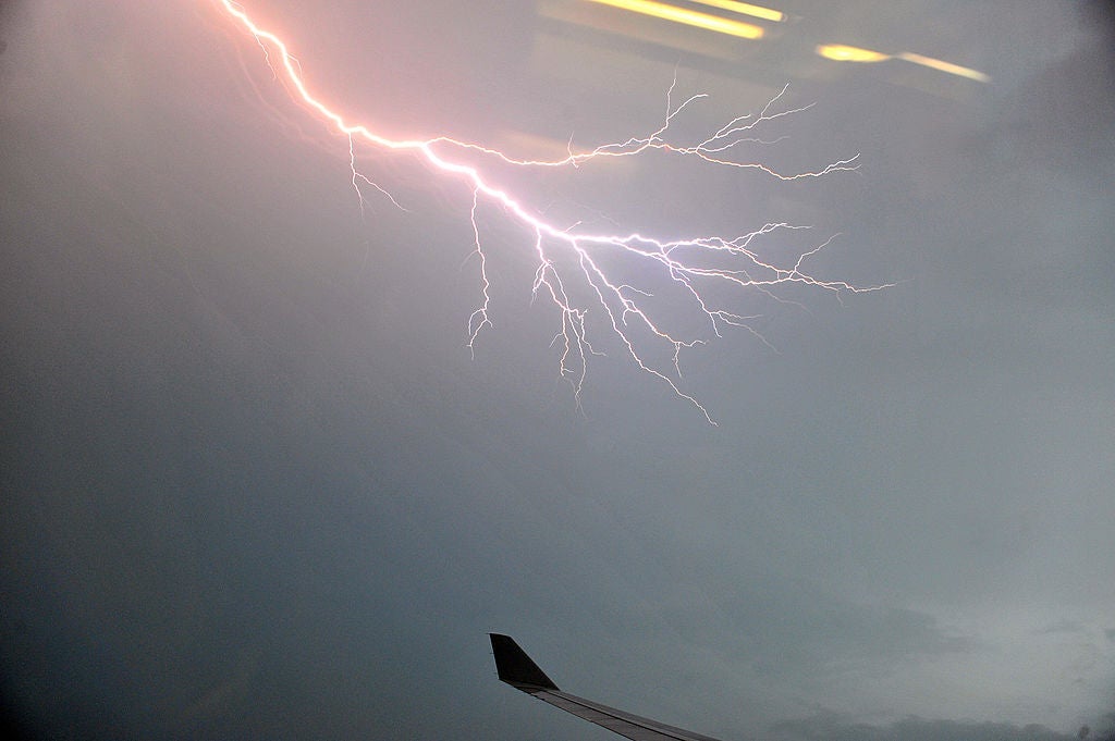
When lightning strikes, the atoms in the fuselage essentially push the energy to the surface, keeping it away from the inside. The aircraft acts as a Faraday Cage. As a result, any damage to the aircraft is limited to the outside, where there may be a few small marks or a couple of the million-plus rivets go missing. As a result, when the aircraft lands, it undergoes a check just to make sure all these marks have been dealt with.
If the conditions are extreme enough, it may be pertinent to delay takeoff or landing until the storm has passed. Whilst on the ground, this will cause delays to your departure. Aircraft already at the runway will wait to takeoff, resulting in a growing queue. If the delays are long enough, it could mean your aircraft has to wait at the gate before departing. As the backlog grows, other aircraft have to wait for parking stands to become available.
In the air, it may mean that your flight will have to enter a holding pattern. However, as thunderstorms are fairly straightforward to forecast, the pilots will have been aware of this possibility. When storms are forecast for the destination airport, we will normally take extra fuel to cover the eventuality of having to delay our landing.
How Pilots Avoid Thunderstorms
All the above may sound a little alarming, but let me be clear about one thing. Every single thing that your pilot does is done to keep you safe. We are paid to make sure that you get safely from A to B. If we can do that on time, brilliant. However, we will never, ever compromise safety. We have our own families. We have our own children. We have our own parties that we want to get to. Weddings that we want to attend. We want to get there safely, too.
So, in order to avoid the effects of thunderstorms and keep you safe, we have a few methods at our disposal.
Forecasts
Before your pilots even step onto the aircraft, they conduct a thorough briefing that includes the weather en route and at the destination. If thunderstorms are forecast, they will take more fuel. This enables them to deviate off their planned route to avoid storms and hold at the destination until the storms have cleared.
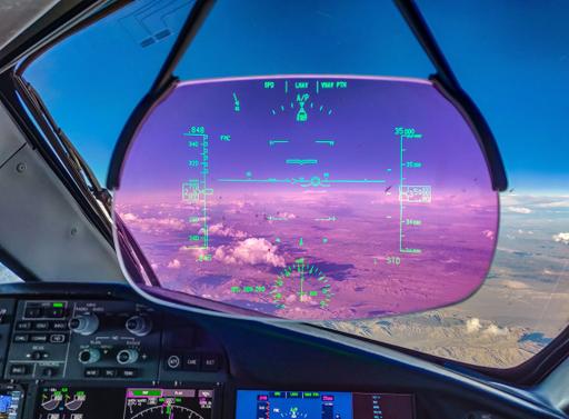
Weather Radar
Once airborne, even with the best of forecasts, the system is extremely dynamic. As I mentioned before, thunderstorms can form in as few as 30 minutes. This is fine if they are well defined during the day, as they are fairly conspicuous. At night, it's a different matter.
To help us detect large clouds in advance, we have a weather radar. By sending out a radar beam, it bounces back off water droplets. The more dense the water droplets, the more dense the cloud. This is why we are able to detect clouds in advance but not turbulence.

The radar returns then show the detected cloud on our navigational display. From this picture, we are then able to decide how best to avoid them.
If possible, we try to fly upwind of thunderstorm clouds. This is because the worst of the turbulence is found downwind of them. Next time you see a large, defined storm, look at which side the top is developing. It always grows on the downwind side.
Pilot Reports and eWAS
New technology is also helping us keep your flight safer. Apps such as eWas not only show an accurate forecast of weather, but they also enable pilots to report weather as it happens. With onboard Wi-Fi, pilots can get a real-time picture of the weather on their route, well in advance of what the radar can give them.

Bottom Line
During a flight, you may have idly looked out the window and noticed some huge clouds. You may have thought it quite lucky that the route took you nicely between them. That doesn't happen with luck.
Whilst you're relaxed in the back, your pilots are constantly monitoring the route. If thunderstorms lie in your path, they will do what's necessary to ensure that the aircraft avoids them, keeping the flight nice and smooth.
TPG featured card

at American Express's secure site
Terms & restrictions apply. See rates & fees.
| 4X | Earn 4X Membership Rewards® points per dollar spent on purchases at restaurants worldwide, on up to $50,000 in purchases per calendar year, then 1X points for the rest of the year. |
| 4X | Earn 4X Membership Rewards® points per dollar spent at US supermarkets, on up to $25,000 in purchases per calendar year, then 1X points for the rest of the year. |
| 5X | New! Earn 5X Membership Rewards® points on prepaid hotel stays booked through AmexTravel.com or the Amex Travel App. |
| 3X | Earn 3X Membership Rewards® points on flights booked through AmexTravel.com, the Amex Travel App, or purchased directly from airlines. |
| 2X | Earn 2X Membership Rewards® points on prepaid car rentals booked through AmexTravel.com or the Amex Travel App and cruises booked and paid through AmexTravel.com. |
| 1X | Earn 1X Membership Rewards® point per dollar spent on all other eligible purchases. |
Pros
- Valuable dining and food-related credits
- Flexible rewards with airline and hotel transfer partners
- Multiple travel and purchase protections
- No foreign transaction fees
- Access to Amex Offers for additional savings (enrollment required)
Cons
- Not as useful for those living outside the U.S.
- Some may have trouble using Uber and other dining credits
- You may be eligible for as high as 100,000 Membership Rewards® Points after you spend $8,000 in eligible purchases on your new Card in your first 6 months of Card Membership. Welcome offers vary and you may not be eligible for an offer. Apply to know if you’re approved and find out your exact welcome offer amount – all with no credit score impact. If you’re approved and choose to accept the Card, your score may be impacted.
- Earn 4X Membership Rewards® points per dollar spent on purchases at restaurants worldwide, on up to $50,000 in purchases per calendar year, then 1X points for the rest of the year.
- Earn 4X Membership Rewards® points per dollar spent at US supermarkets, on up to $25,000 in purchases per calendar year, then 1X points for the rest of the year.
- New! Earn 5X Membership Rewards® points on prepaid hotel stays booked through AmexTravel.com or the Amex Travel App.
- Earn 3X Membership Rewards® points on flights booked through AmexTravel.com, the Amex Travel App, or purchased directly from airlines.
- Earn 2X Membership Rewards® points on prepaid car rentals booked through AmexTravel.com or the Amex Travel App and cruises booked and paid through AmexTravel.com.
- Earn 1X Membership Rewards® point per dollar spent on all other eligible purchases.
- Pay It® lets you tap in the American Express® App to quickly pay for small purchase amounts throughout the month and still earn rewards the way you usually do. Plan It® gives you the option to split up big purchases into equal monthly payments with a fixed fee. You’ll know upfront exactly how much you’ll pay.
- Updated! $120 Dining Credit: Earn up to a total of $10 in statement credits monthly when you pay with the Gold Card at Grubhub (including Seamless), Buffalo Wild Wings, Five Guys, The Cheesecake Factory, and Wonder. This can be an annual savings of up to $120. Enrollment required.
- $100 Resy Credit: Get up to $100 in statement credits each calendar year at over 10,000 qualifying U.S. Resy restaurants after you pay for eligible purchases with the American Express® Gold Card. That’s up to $50 in statement credits semi-annually. Enrollment required.
- $84 Dunkin' Credit: Earn up to $7 in monthly statement credits after you pay with the American Express® Gold Card at U.S. Dunkin’ locations. Enrollment required.
- $120 Uber Cash on Gold: Enjoy up to $120 in Uber Cash annually with your Gold Card. Just add your Card to your Uber account and you'll get $10 in Uber Cash each month to use on orders and rides in the U.S. when you select an Amex Card for your transaction.
- New! As an American Express® Gold Card Member, you can enjoy complimentary Hertz Five Star® Status. Enjoy benefits like skipping the counter at select locations, adding an additional driver at no additional cost*, and vehicle upgrades**. Benefit enrollment and Hertz Gold+ registration are required. *Additional drivers must meet standard rental qualifications and must be a spouse or domestic partner to qualify as complimentary. Other additional drivers subject to fees. **Benefits are subject to availability and vary by location. Additional Hertz program Terms and Conditions including age restrictions apply.
- Take advantage of a $100 credit towards eligible charges* at over 1,300 upscale hotels worldwide when you book The Hotel Collection through AmexTravel.com or the Amex Travel App **. *Eligible charges vary by property. **The Hotel Collection requires a two-night minimum stay.
- Book your travel through the Amex Travel App with added peace of mind – backed by American Express® service and support. Only for American Express® Card Members.
- Whenever you need us, we're here. Our Member Services team will ensure you are taken care of. From lost Card replacement to statement questions, we are available to help 24/7.
- No Foreign Transaction Fees.
- Annual Fee is $325.
- Terms Apply.