How pilots deal with tropical storms
As I wrote this, Tropical Storm Elsa was making its way towards South Florida.
I'm sure you are familiar with the effects storms like this have on the ground, but what about on those in the air?
The strong winds, thunderstorms and heavy rain that come with tropical storms can all pose a hazard to aviation. As a result, pilots pay careful attention to weather forecasts and plan ahead to keep their aircraft, and their passengers, safe.
How do tropical storms form?
The tropical storms which affect the Caribbean and Eastern Seaboard of the United States are most prevalent between June and November. Even though their impact has the greatest effect on the western side of the Atlantic, these weather systems actually begin thousands of miles away in sub-Saharan Africa.
Over the highlands of Ethiopia, a ripple in the upper atmosphere, known as an Easterly Wave, sparks off a chain of events that ultimately will lead to the giant weather systems which we know as tropical storms and hurricanes. Traveling westwards across Africa, this wave creates a line of thunderstorms.

The king of weather phenomena, it is estimated that there are around 40,000 thunderstorms around the world in a given 24-hour period. They are synonymous with heavy rain, strong winds and severe turbulence.
Thunderstorms need three elements to form: a source of moisture to give them substance, a source of lift to help them grow and unstable air to continue that growth. As a result, when meteorologists see these three factors are present, they can quite easily predict that thunderstorms are likely.
Related: How pilots keep you safe and comfortable during inclement weather
Moisture
Clouds are just condensed water vapor that forms around microscopic nuclei — anything solid that can act as a core, for example, smoke or dust particles. For any cloud to form, there has to be a source of moisture. More often than not, this comes from the oceans.

However, the temperature of the water also plays a big part in how likely CBs are to form. Evaporation is more prevalent in warm water systems. As a result, more moisture is put into the atmosphere compared with areas of cold water.
Lift
Once there is moisture in the air, it needs a source of lift to allow it to climb and form a cloud. This lift comes from variations in the air density, which is affected by a number of elements.
During the day, the sun heats the surface of the earth. As the surface heats up, some of that heat is transferred into the air. However, this heating isn't uniform as some areas heat up quicker than others.
This creates columns of air above the ground at different temperatures. As the cooler air is heavier, it sinks. As it sinks, it spills over into the area of warmer air, pushing the warm air column even high up. These columns of moving cool and warm air are called thermals.
Instability
Even if the air has a source of lift, unless it can keep growing, thunderstorms will not form. This is where instability comes in. If an object is pushed upwards and continues to rise, the air is considered to be unstable. It normally occurs when cold, dry air sits on top of warm, moist air.
When these conditions occur, if a mass of the warm, moist air is pushed upwards, it continues to climb. However, as height increases, the air cools. When this happens, some of the water vapor condenses to form distinguishable thunderstorm clouds. As this vapor cools more, it falls as rain and sometimes as hail.
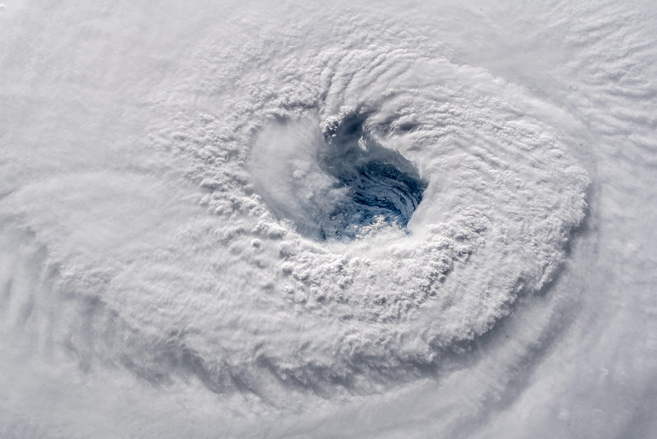
When these storms hit the warm water of the Atlantic, things really begin to kick off. With the added available moisture, the thunderstorms being to grow in height and, due to the spinning of the earth, these storms begin to rotate. As this cluster of storms continues to move westward across the ocean, the bigger the thunderstorms grow, the more they rotate.
Eventually, this collection of storms form into one giant rotating mass. As the winds reach 39 mph, the mass is classified as a tropical storm and once they reach 74 mph, it becomes a hurricane.
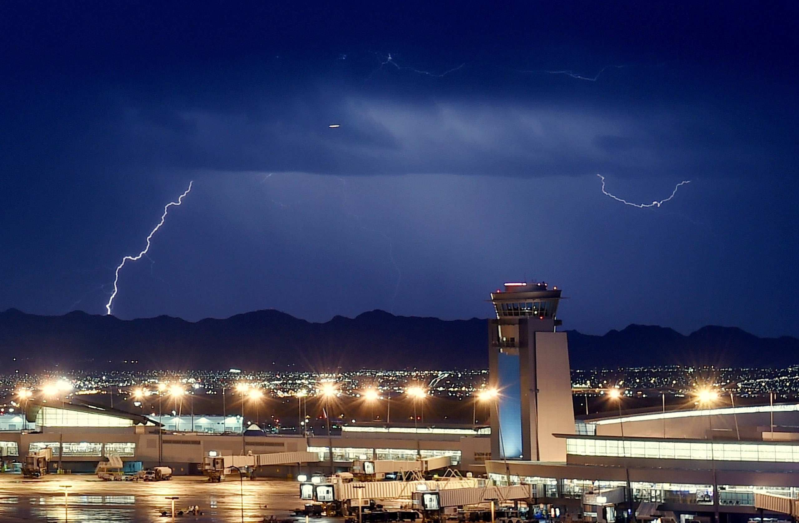
When it comes to aviation, tropical storms bring several weather phenomena that pilots must respect. The combination of strong winds, thunderstorms and heavy rain can be dangerous to flying conditions if the pilots do not take the right steps.
Strong Winds
Most turbulence is caused by fluctuations in the wind's velocity — its speed and direction. It is what's commonly known as Clear Air Turbulence, or CAT. To understand why this causes turbulence, we need a basic physics lesson.
Related: How pilots keep you safe while flying through strong winds
Airflow over the wing generates lift. As the aircraft accelerates down the runway, the airflow over the wing increases. When this airflow reaches a critical point, enough lift is generated by the wings to enable the aircraft to leave the ground and start climbing up into the air. The engines merely provide the acceleration, the wings do the actual flying.
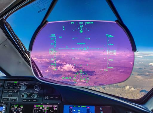
In the cruise
However, once up in the air, the airflow over the wing isn't always constant. Variations in the wind speed and direction mean that at one moment there is more lift, the next moment there is less lift. Multiply this hundreds of times per second and this is what gives you turbulence. The greater the difference in the variations of lift, the great the bumps experienced. This is the case when flying near a tropical storm.
Related: What do pilots do during the cruise?
To help smooth this out, the wings act very much like the suspension on your car. When driving down a country road, the suspension rises and falls to dampen the effects each bump has on the passengers. On an aircraft, the wings are designed to flex and bend to have the same dampening effect, as can be seen in the video below. Whilst it may look alarming to see the wings flexing like this, they are not only doing what they are meant to do but they are even designed to bend far more than any turbulence could make them.
From the pilot's perspective, turbulence like this is merely an inconvenience. We know that the aircraft is designed to endure forces far greater than any weather system we can expect to encounter. The biggest threat comes from loose items, or people, inside the aircraft. In the cruise, it's a matter of switching the seatbelt signs on and making sure that all passengers are safely secured in their seats.
We'll normally slow down a little to enable the aircraft to ride the bumps a bit better and keep a close eye on the airspeed. Sometimes we are able to change our cruising altitude where ATC has had reports that it is smoother. However, quite often, if it's bumpy at one altitude, it will be bumpy at all altitudes. In these situations, it's just a case of riding it out until the conditions start to smooth.
On the Approach
When the wind gets really strong, windshear becomes a factor. Windshear is defined as a sudden change of wind velocity and/or direction. Now, this may sound the same as turbulence, however, windshear is commonly referred to in the stages of flight close to the ground.
We already know that lift is generated by airflow passing over the wings. If that airflow changes rapidly, the lift can suddenly increase, or worse, decrease. If this happens close to the ground, the results can be somewhat undesirable.
Entry into windshear conditions can be confirmed by the windshear warning, a two-tone siren followed by "WINDSHEAR, WINDSHEAR, WINDSHEAR," or unacceptable flight path deviations. These deviations can be recognized by changes to the flight conditions greater than 15kts airspeed, 5 degrees pitch attitude, 500 feet per minute descent or climb rate and significant deviation from the vertical approach slope.
The reaction of the pilots to entering windshear conditions is to perform the Windshear Escape Manoeuvre. In essence, this means applying full engine power and breaking off the approach and back up to a safe altitude, like in the video below.
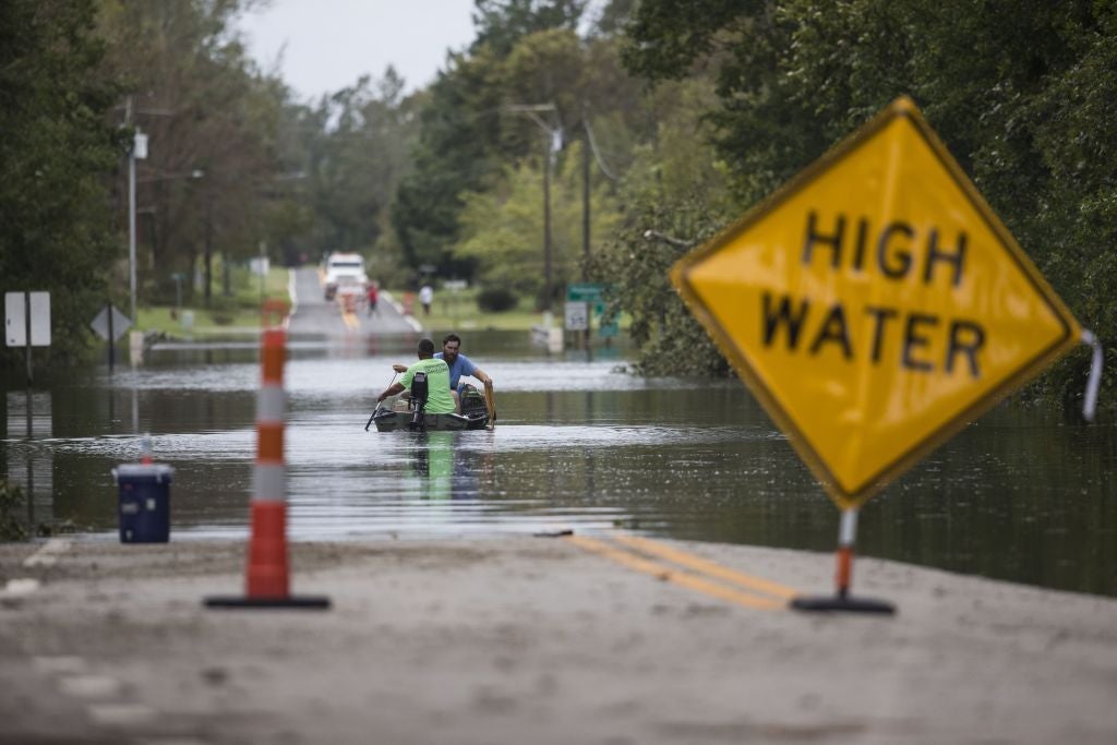
Heavy Rain
Heavy rain isn't much of a problem for aircraft in the air. During the design phase, the engines are tested to ensure that they can take the worst of what the weather can throw at them. The video below shows how tons of water and ice are forced into the engines and they continue to operate perfectly.
However, once the wheels are on the ground, it's time for the wheel brakes to start to slow the aircraft. However, like in your car, the condition of the runway surface can have a huge effect on the effectiveness of the brakes.
As you might imagine, the ideal conditions to land are on a dry runway. With maximum friction between the tires and the runway, the brakes are far more effective. However, a dry runway isn't always possible, particularly when tropical storms are a factor.
If the airfield weather states that it is raining, or it may rain during the time of landing, pilots will treat the runway as wet and calculate the performance accordingly. Rain is fairly common, so a wet runway is nothing abnormal. However, what happens when the rain is extremely heavy and doesn't drain away from the runway efficiently?
With a large volume of water on the runway, braking efficiency can be greatly reduced. As a result, it's important that we know just how deep the water on the runway is.
As we approach the airport, we obtain the latest airfield information, including the state of the runways. We then refer to the table below which is found in our operational manuals.
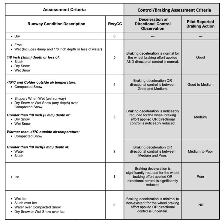
Taking the depth of water into consideration, we can then accurately calculate how much runway we will require for the actual conditions to stop safely. If this value is greater than the landing distance available, we will either have to wait till the water drains away or divert to another airfield.
Planning Ahead
For pilots scheduled to fly across the Atlantic to Florida in the next few days, their planning will quite often begin days in advance. As professionals, we always keep abreast of weather conditions around the world, keeping an eye on major events such as hurricanes and snowstorms.
With that in mind, they will most likely be keeping an eye on the path of the storm to see how close it will be to their destination.
Related: Flight planning: The unseen detail behind every flight
Extra fuel
The best time to make a good decision is at a time of low workload. When it comes to flying an airliner, the time of lowest workload is before we even get on the aircraft, in the briefing room.
Here, we meet up around two hours before departure to discuss the weather for our route and at the destination.
If it looks like there will be significant weather at the destination, weather which may prevent us from landing, we need to have a backup plan.
For pilots, fuel equals time. Therefore the more fuel we have, the more time we have. If it looks like we may have to wait to make an approach to land, or that a go-around could be likely due to the weather, we will decide to load more fuel.
We also carry enough fuel to divert to an alternate airport, in case we are unable to get to our destination. Quite often, this will be an airfield nearby.
However, if the weather at the alternate looks similarly challenging as the destination, we may decide to use an alternative that is further away. Once again, this means loading more fuel.
As a result, even before we take off, we have a plan for the arrival. We will know how long we can wait to make an approach before we have to divert to the alternate.
To have this decision made hours earlier in the calm of the briefing room makes life a lot easier when the workload ramps up near the destination.
Bottom line
Tropical storms and hurricanes pose a significant threat to flight safety. As a result, pilots give them the respect which they deserve.
Strong winds, thunderstorms and heavy rain all bring their challenges when trying to land an aircraft. To deal with these, pilots have a number of techniques available to them to ensure that the safety of the aircraft and its occupants is never jeopardized.
Taking extra fuel buys us time. Time to wait until the weather clears, time to divert to another airfield or, time to make another decision.
TPG featured card

at American Express's secure site
Terms & restrictions apply. See rates & fees.
| 4X | Earn 4X Membership Rewards® points per dollar spent on purchases at restaurants worldwide, on up to $50,000 in purchases per calendar year, then 1X points for the rest of the year. |
| 4X | Earn 4X Membership Rewards® points per dollar spent at US supermarkets, on up to $25,000 in purchases per calendar year, then 1X points for the rest of the year. |
| 5X | New! Earn 5X Membership Rewards® points on prepaid hotel stays booked through AmexTravel.com or the Amex Travel App. |
| 3X | Earn 3X Membership Rewards® points on flights booked through AmexTravel.com, the Amex Travel App, or purchased directly from airlines. |
| 2X | Earn 2X Membership Rewards® points on prepaid car rentals booked through AmexTravel.com or the Amex Travel App and cruises booked and paid through AmexTravel.com. |
| 1X | Earn 1X Membership Rewards® point per dollar spent on all other eligible purchases. |
Pros
- Valuable dining and food-related credits
- Flexible rewards with airline and hotel transfer partners
- Multiple travel and purchase protections
- No foreign transaction fees
- Access to Amex Offers for additional savings (enrollment required)
Cons
- Not as useful for those living outside the U.S.
- Some may have trouble using Uber and other dining credits
- You may be eligible for as high as 100,000 Membership Rewards® Points after you spend $8,000 in eligible purchases on your new Card in your first 6 months of Card Membership. Welcome offers vary and you may not be eligible for an offer. Apply to know if you’re approved and find out your exact welcome offer amount – all with no credit score impact. If you’re approved and choose to accept the Card, your score may be impacted.
- Earn 4X Membership Rewards® points per dollar spent on purchases at restaurants worldwide, on up to $50,000 in purchases per calendar year, then 1X points for the rest of the year.
- Earn 4X Membership Rewards® points per dollar spent at US supermarkets, on up to $25,000 in purchases per calendar year, then 1X points for the rest of the year.
- New! Earn 5X Membership Rewards® points on prepaid hotel stays booked through AmexTravel.com or the Amex Travel App.
- Earn 3X Membership Rewards® points on flights booked through AmexTravel.com, the Amex Travel App, or purchased directly from airlines.
- Earn 2X Membership Rewards® points on prepaid car rentals booked through AmexTravel.com or the Amex Travel App and cruises booked and paid through AmexTravel.com.
- Earn 1X Membership Rewards® point per dollar spent on all other eligible purchases.
- Pay It® lets you tap in the American Express® App to quickly pay for small purchase amounts throughout the month and still earn rewards the way you usually do. Plan It® gives you the option to split up big purchases into equal monthly payments with a fixed fee. You’ll know upfront exactly how much you’ll pay.
- Updated! $120 Dining Credit: Earn up to a total of $10 in statement credits monthly when you pay with the Gold Card at Grubhub (including Seamless), Buffalo Wild Wings, Five Guys, The Cheesecake Factory, and Wonder. This can be an annual savings of up to $120. Enrollment required.
- $100 Resy Credit: Get up to $100 in statement credits each calendar year at over 10,000 qualifying U.S. Resy restaurants after you pay for eligible purchases with the American Express® Gold Card. That’s up to $50 in statement credits semi-annually. Enrollment required.
- $84 Dunkin' Credit: Earn up to $7 in monthly statement credits after you pay with the American Express® Gold Card at U.S. Dunkin’ locations. Enrollment required.
- $120 Uber Cash on Gold: Enjoy up to $120 in Uber Cash annually with your Gold Card. Just add your Card to your Uber account and you'll get $10 in Uber Cash each month to use on orders and rides in the U.S. when you select an Amex Card for your transaction.
- New! As an American Express® Gold Card Member, you can enjoy complimentary Hertz Five Star® Status. Enjoy benefits like skipping the counter at select locations, adding an additional driver at no additional cost*, and vehicle upgrades**. Benefit enrollment and Hertz Gold+ registration are required. *Additional drivers must meet standard rental qualifications and must be a spouse or domestic partner to qualify as complimentary. Other additional drivers subject to fees. **Benefits are subject to availability and vary by location. Additional Hertz program Terms and Conditions including age restrictions apply.
- Take advantage of a $100 credit towards eligible charges* at over 1,300 upscale hotels worldwide when you book The Hotel Collection through AmexTravel.com or the Amex Travel App **. *Eligible charges vary by property. **The Hotel Collection requires a two-night minimum stay.
- Book your travel through the Amex Travel App with added peace of mind – backed by American Express® service and support. Only for American Express® Card Members.
- Whenever you need us, we're here. Our Member Services team will ensure you are taken care of. From lost Card replacement to statement questions, we are available to help 24/7.
- No Foreign Transaction Fees.
- Annual Fee is $325.
- Terms Apply.