Warnings issued for Carolinas, new airport announces closure as Hurricane Dorian turns north

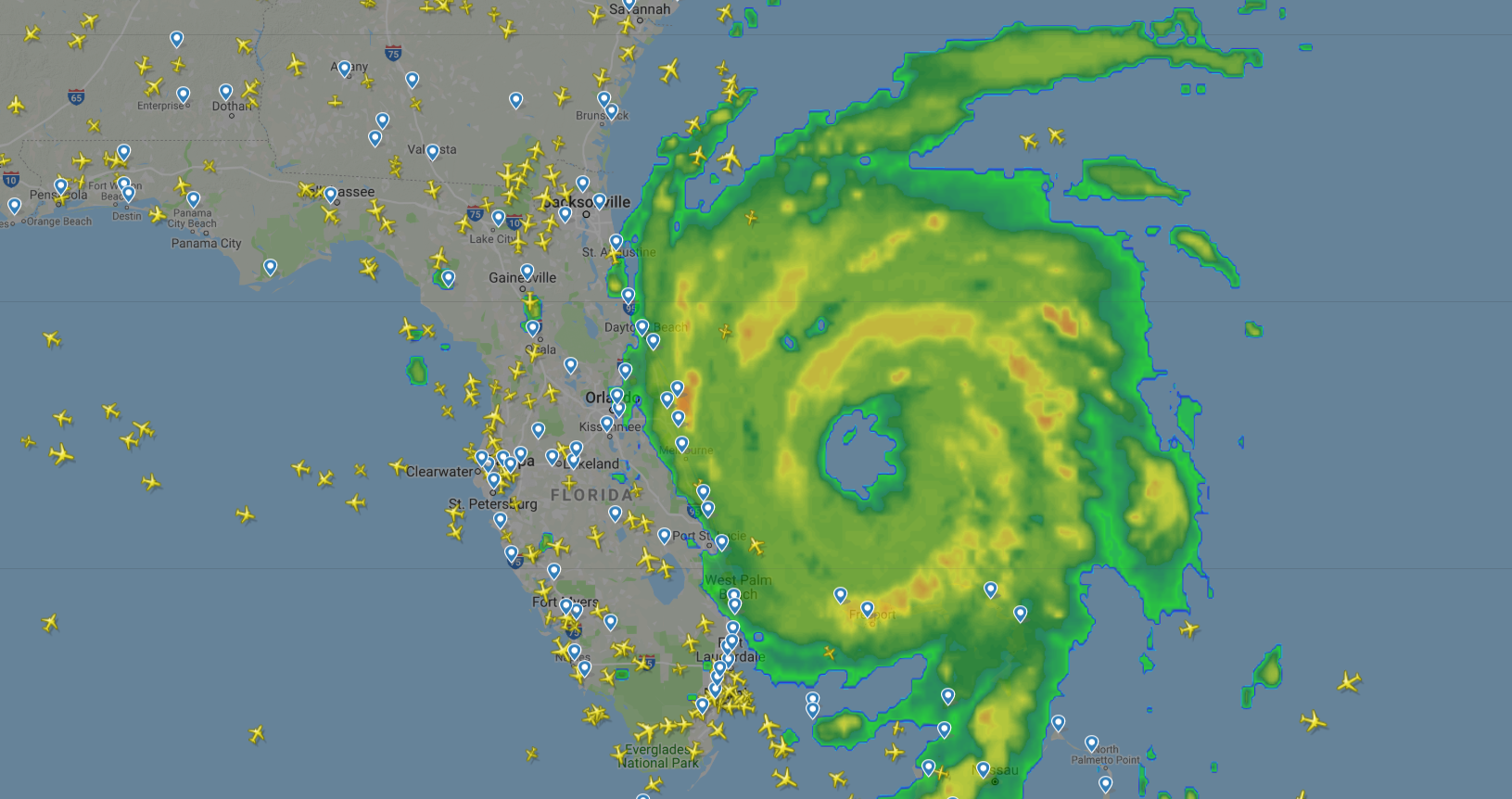
Hurricane Dorian has started its long-expected northward turn after devastating the northern Bahamas over the past few days. While that's good news for those in the Bahamas and South Florida, it's not good news for northern Florida, Georgia and the Carolinas.
Hurricane Dorian was always expected to make a close pass when heading north, but models now show the expected path shifted slightly west — increasing the chances of a landfall along the South Carolina or North Carolina coast. That's led to the first announced airport closure outside of Florida — Charleston, South Carolina — as the storm begins its march up the coast.
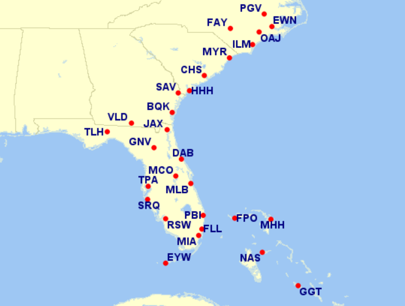
Airline weather waivers now stretch across 24 airports in Florida, Georgia, South Carolina and North Carolina as well as four airports in the Bahamas:
Forecast
As of Tuesday's 5 p.m. ET update from the National Hurricane Center, Hurricane Dorian's top sustained winds have decreased to 110 mph — a Category 2 hurricane. It's expected to maintain 110 mph wind speeds for the next 36 hours before weakening slightly on Thursday afternoon.
The center of the official track as of 5 p.m. ET keeps the hurricane from making landfall on the East Coast of the US. However, the center of the forecast track is closer to the coast than in the past few days, and the South Carolina and North Carolina coasts are very much in the cone of uncertainty.
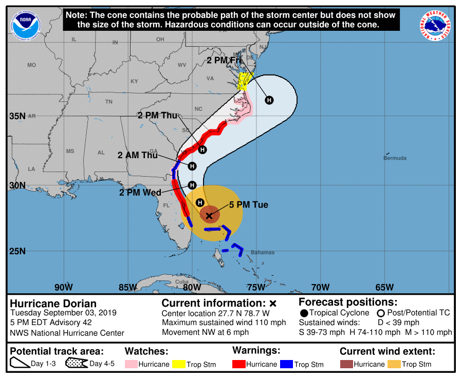
Despite the decrease in wind speed, Dorian remains a powerful hurricane. The wind field has expanded considerably from when it made landfall on the Bahamas, with hurricane-force winds now extending 50 nautical miles (58 standard miles) and tropical storm winds reaching up to 150 nautical miles (173 standard miles) from the center.
While all models are now in agreement that the center of the storm will stay off of the Florida coast, the proximity to the Florida coast are expected to cause flooding and strong winds into Thursday. Tropical storm winds are likely to reach the Georgia coast early Wednesday and the South Carolina coast Wednesday evening.
Coastal Impact
Even with the eye staying off of the coast, both Florida and the Carolinas may still get hurricane force winds as the storm passes. Hurricane Warnings are currently in effect from Sebastian Inlet to Ponte Vedra Beach in Florida and from the Savannah River that separates Georgia and South Carolina to Surf City, North Carolina — indicating that hurricane force winds are expected within 36 hours.
In addition, a Storm Surge Warning is in effect from Jupiter Inlet, Florida, to Surf City, North Carolina with up to 7 feet of storm surge expected in parts.

Evacuation orders are in place up the coast of Florida — including St. Augustine, Jacksonville, Georgia (east of I-95) and the coastal areas of South Carolina:
Between 3 and 6 inches of rain are expected in Florida and Georgia. However, rainfall could reach up to 15 inches along the Carolina coast later this week.
Airport Closures
Check this post for the latest updates on what airports are closed and when they'll reopen
Charleston International Airport (CHS) has become the first US airport outside of Florida to announce its closure for Hurricane Dorian. The airport will close to all flights at 3pm local time on Wednesday:
Orlando International Airport (MCO) closed overnight Monday night. It's indicated to the FAA that it will reopen Wednesday afternoon. However, that reopen time could be delayed.
Palm Beach International (PBI) closed on Monday and planned to reopen Tuesday, but the reopening has been pushed back to sometime Wednesday:
Daytona Beach International Airport (DAB) closed at 6 p.m. on Monday and currently doesn't plan to reopen until Thursday night -- according to the FAA:
Further up the coast, Jacksonville International Airport (JAX) expects it will remain open through Wednesday:
Flight Cancellations
Through midday Tuesday, there have been over 3,000 flight cancellations across just six Florida airports due to Hurricane Dorian. Additional cancellations are expected in northern Florida, South Carolina and North Carolina as the storm passes.
Although it's generally held off cancelling flights until the last minute, Delta has announced 180 flight cancellations Tuesday and Wednesday due to airport closures at West Palm Beach, Orlando, Melbourne, Daytona Beach in Florida and at Brunswick in Georgia.
As of 2 p.m. Tuesday, American Airlines reports cancelling 350 flights on Tuesday, 180 flights on Wednesday and 40 flights on Thursday.
Fare Caps
American Airlines is capping fares from eight Georgia, North Carolina and South Carolina airports through Sept. 7. In addition, American Airlines has capped fares at $499 one-way nonstop in economy or $699 in domestic first class for flights out of Florida through Sept. 4.
Delta's fare cap on flights out of specified Florida and Georgia airports is only applicable for flights through Sept. 4. Flights are capped at between $299-$599 in Main Cabin and $499-$799 in the forward cabin based on the flight distance.
Fee Waivers
American Airlines and Delta are both waiving checked-bag and pet fees for certain airports covered by travel waivers.
American Airlines is waiving fees for two checked bags and in-cabin pets for flights to/from all cities covered under the travel alert in Florida, Georgia, North Carolina and South Carolina. These fees are waived through Sept. 7.
Delta's waiver only lasts through Sept. 4 from seven Florida airports.
Most US airlines have issued weather advisories for Florida, Georgia, South Carolina and North Carolina, allowing flexible travelers the chance to rebook away from the storm. Current waivers cover 24 airports on the US Southeast Coast and four airports in the Bahamas. Here are the latest waivers:
TPG featured card

at American Express's secure site
Terms & restrictions apply. See rates & fees.
| 4X | Earn 4X Membership Rewards® points per dollar spent on purchases at restaurants worldwide, on up to $50,000 in purchases per calendar year, then 1X points for the rest of the year. |
| 4X | Earn 4X Membership Rewards® points per dollar spent at US supermarkets, on up to $25,000 in purchases per calendar year, then 1X points for the rest of the year. |
| 5X | New! Earn 5X Membership Rewards® points on prepaid hotel stays booked through AmexTravel.com or the Amex Travel App. |
| 3X | Earn 3X Membership Rewards® points on flights booked through AmexTravel.com, the Amex Travel App, or purchased directly from airlines. |
| 2X | Earn 2X Membership Rewards® points on prepaid car rentals booked through AmexTravel.com or the Amex Travel App and cruises booked and paid through AmexTravel.com. |
| 1X | Earn 1X Membership Rewards® point per dollar spent on all other eligible purchases. |
Pros
- Valuable dining and food-related credits
- Flexible rewards with airline and hotel transfer partners
- Multiple travel and purchase protections
- No foreign transaction fees
- Access to Amex Offers for additional savings (enrollment required)
Cons
- Not as useful for those living outside the U.S.
- Some may have trouble using Uber and other dining credits
- You may be eligible for as high as 100,000 Membership Rewards® Points after you spend $8,000 in eligible purchases on your new Card in your first 6 months of Card Membership. Welcome offers vary and you may not be eligible for an offer. Apply to know if you’re approved and find out your exact welcome offer amount – all with no credit score impact. If you’re approved and choose to accept the Card, your score may be impacted.
- Earn 4X Membership Rewards® points per dollar spent on purchases at restaurants worldwide, on up to $50,000 in purchases per calendar year, then 1X points for the rest of the year.
- Earn 4X Membership Rewards® points per dollar spent at US supermarkets, on up to $25,000 in purchases per calendar year, then 1X points for the rest of the year.
- New! Earn 5X Membership Rewards® points on prepaid hotel stays booked through AmexTravel.com or the Amex Travel App.
- Earn 3X Membership Rewards® points on flights booked through AmexTravel.com, the Amex Travel App, or purchased directly from airlines.
- Earn 2X Membership Rewards® points on prepaid car rentals booked through AmexTravel.com or the Amex Travel App and cruises booked and paid through AmexTravel.com.
- Earn 1X Membership Rewards® point per dollar spent on all other eligible purchases.
- Pay It® lets you tap in the American Express® App to quickly pay for small purchase amounts throughout the month and still earn rewards the way you usually do. Plan It® gives you the option to split up big purchases into equal monthly payments with a fixed fee. You’ll know upfront exactly how much you’ll pay.
- Updated! $120 Dining Credit: Earn up to a total of $10 in statement credits monthly when you pay with the Gold Card at Grubhub (including Seamless), Buffalo Wild Wings, Five Guys, The Cheesecake Factory, and Wonder. This can be an annual savings of up to $120. Enrollment required.
- $100 Resy Credit: Get up to $100 in statement credits each calendar year at over 10,000 qualifying U.S. Resy restaurants after you pay for eligible purchases with the American Express® Gold Card. That’s up to $50 in statement credits semi-annually. Enrollment required.
- $84 Dunkin' Credit: Earn up to $7 in monthly statement credits after you pay with the American Express® Gold Card at U.S. Dunkin’ locations. Enrollment required.
- $120 Uber Cash on Gold: Enjoy up to $120 in Uber Cash annually with your Gold Card. Just add your Card to your Uber account and you'll get $10 in Uber Cash each month to use on orders and rides in the U.S. when you select an Amex Card for your transaction.
- New! As an American Express® Gold Card Member, you can enjoy complimentary Hertz Five Star® Status. Enjoy benefits like skipping the counter at select locations, adding an additional driver at no additional cost*, and vehicle upgrades**. Benefit enrollment and Hertz Gold+ registration are required. *Additional drivers must meet standard rental qualifications and must be a spouse or domestic partner to qualify as complimentary. Other additional drivers subject to fees. **Benefits are subject to availability and vary by location. Additional Hertz program Terms and Conditions including age restrictions apply.
- Take advantage of a $100 credit towards eligible charges* at over 1,300 upscale hotels worldwide when you book The Hotel Collection through AmexTravel.com or the Amex Travel App **. *Eligible charges vary by property. **The Hotel Collection requires a two-night minimum stay.
- Book your travel through the Amex Travel App with added peace of mind – backed by American Express® service and support. Only for American Express® Card Members.
- Whenever you need us, we're here. Our Member Services team will ensure you are taken care of. From lost Card replacement to statement questions, we are available to help 24/7.
- No Foreign Transaction Fees.
- Annual Fee is $325.
- Terms Apply.