Highways in the Sky: How Your Flight Gets Its Path Over the Ocean
Ever wondered what route your plane takes to fly across the Atlantic or Pacific, or how the pilots have the route chosen for them? Chances are you've followed your route along on the seatback screen. Here's how that route comes to be for the North Atlantic (with similar systems for the Pacific and Australia).
Highways in the Sky: The North Atlantic Organized Track System
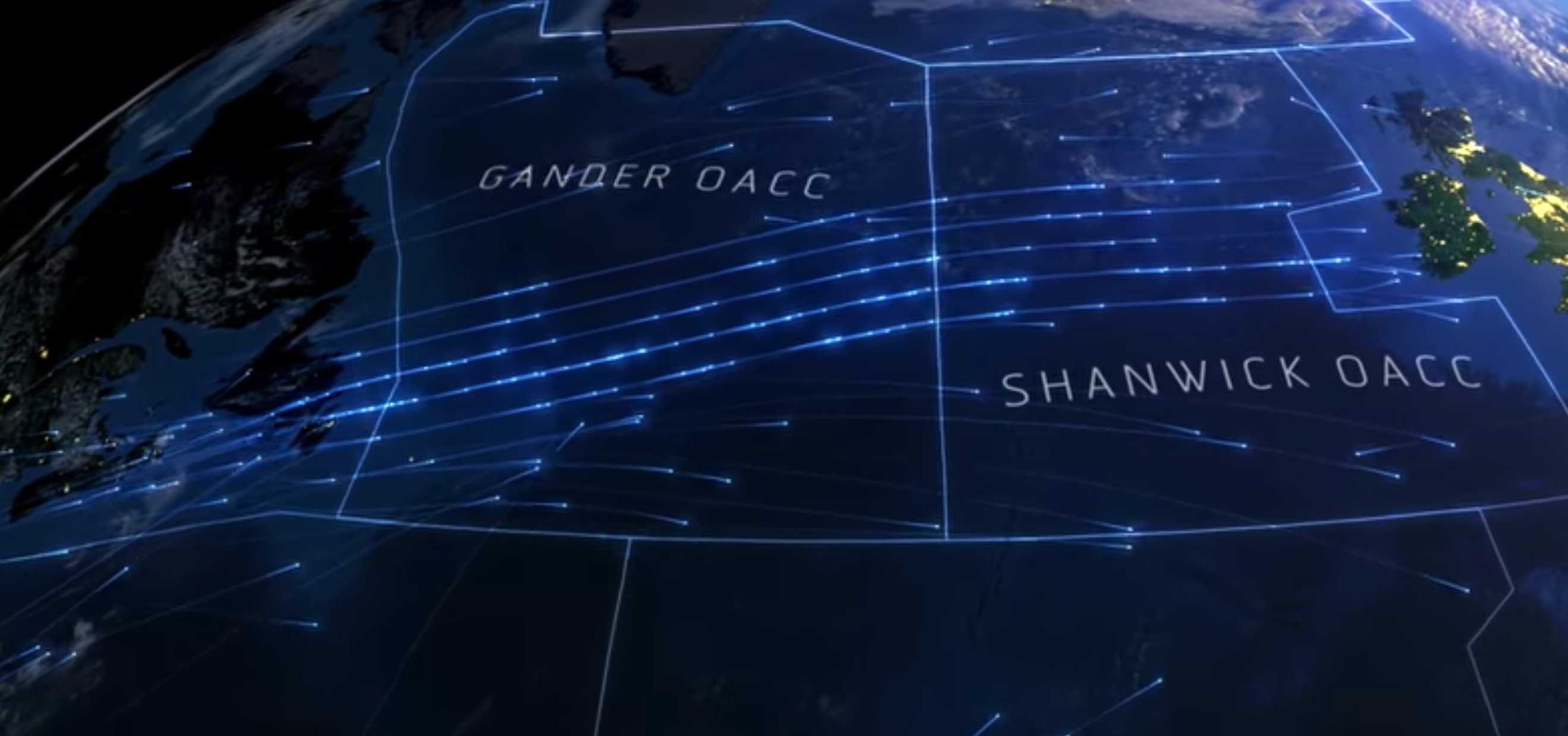
Meet the North Atlantic Organized Track System, a coordinated system of efficient routes from North America to Europe (during the eastbound, evening flights) and the reverse (during westbound, daytime flights). These tracks are essentially highways in the sky.
The actual courses aircraft fly are modified daily by oceanic controllers, located in Gander, Newfoundland, and Prestwick, Scotland. The controllers factor the jet stream; in the North Atlantic it flows eastward at upwards of 150 mph between 30,000 feet and 40,000 feet. Planes and airlines like to fly here for the fuel and time savings on the way over and use the information to minimize headwinds on the way back.
"There is such a dense traffic," Guillaume Laffon, an Air France pilot, told TPG. "Generally, from flight level 340 until 430, there are planes every 1,000 feet. New improvements have been made to increase the traffic on those routes, including RLAT (Reduced Lateral Separation), which puts planes at 4 nautical miles apart."
The use of these flight levels is different than the jet routes across North America, which do not change daily.

The airspace is indeed busy. Each of Gander and Shanwick (an amalgam of Shannon, Ireland, and Prestwick, Scotland where two centers are now one) process up to 1,500 flights per day during the busy summer travel period.
"Dispatch and Air France operations play a big role in the preparation of a flight like this," said Laffon. "A computer system chooses the best one of the day, meaning with the lowest cost, including fuel, winds, weather, particularities on this route and destination." The operations team will make a request with Gander or Shanwick as the case may be earlier in the day."We [pilots] decide if we are ok with the choice of the system and the dispatcher for this mission, because, in the end, we are the leaders of the mission and we have to ensure the maximum level of safety for our passengers," Laffon said.
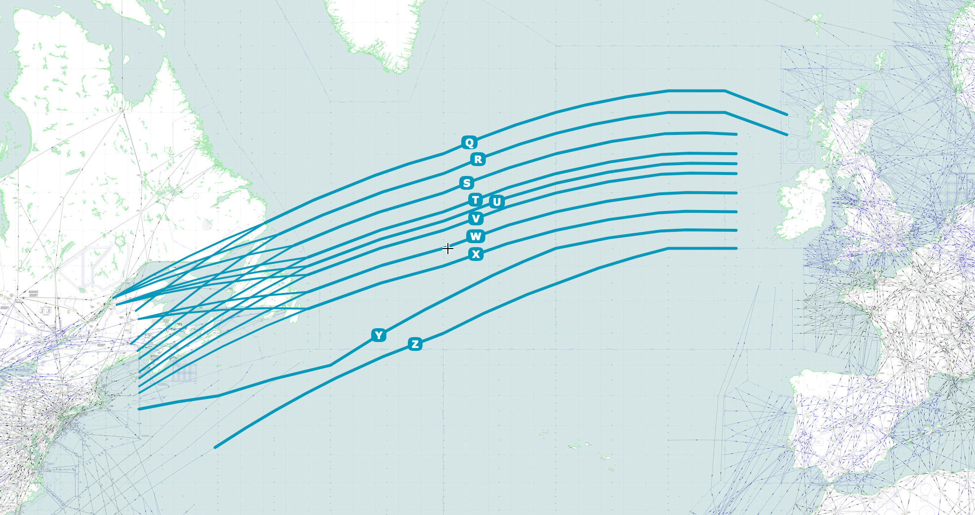
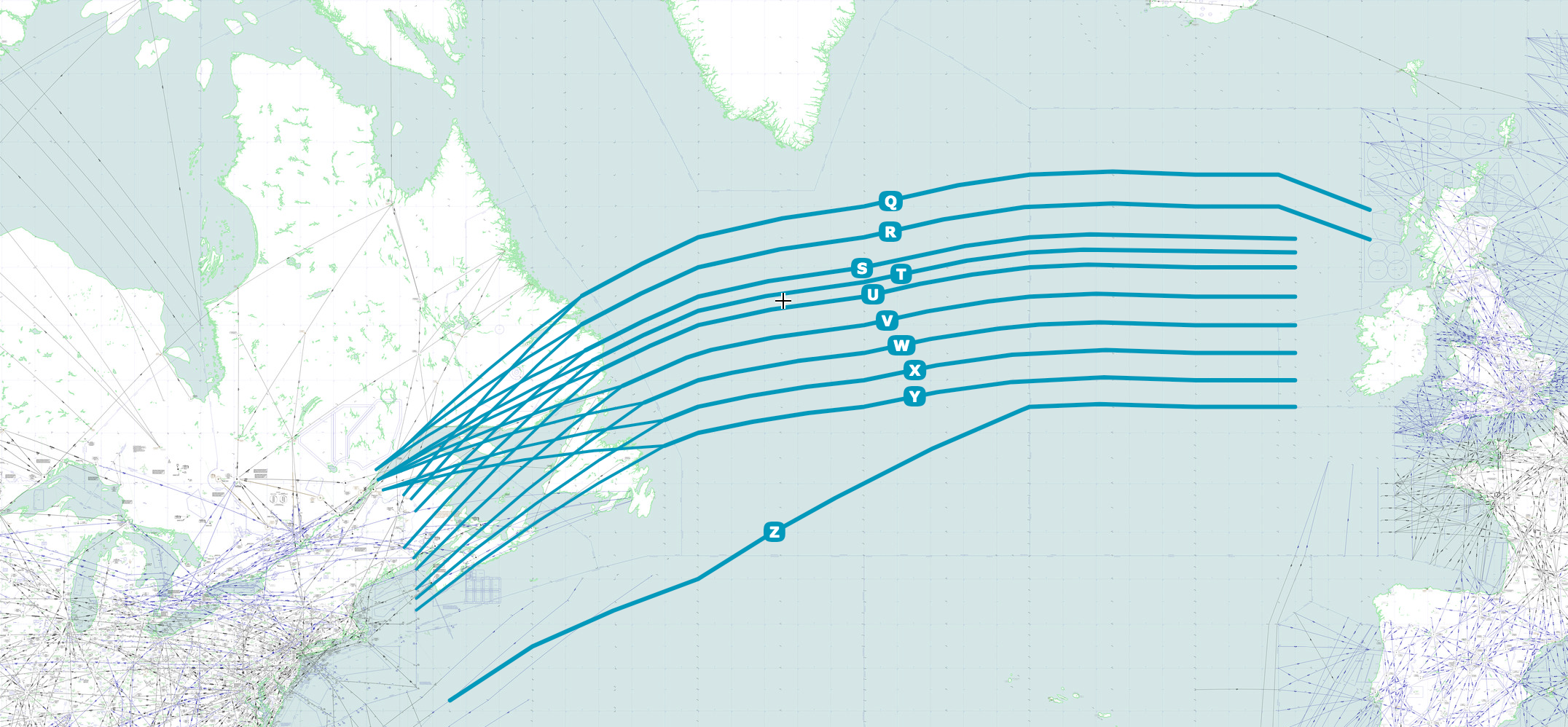
The tracks are lettered, with northernmost westbound tracks Track A and the southernmost eastbound tracks Track Z. The eastbound tracks are reflected in the images below.
North Atlantic Tracks - Eastbound Day 1

North Atlantic Tracks - Eastbound Day 2
If you compare the above tracks, you can see that the tracks are slightly different the next day. Track Y is more southerly on Day 1, and there are slight distinctions between tracks Q and X.
Similarly, there are tracks that are flown from the west coast of the US to Asia and back called the PACOTS. The same goes for down under where the AUSOTS rule the day.
You may notice that the tracks above do not continue to LHR or show the departure from JFK. Indeed, they terminate at fixed waypoints that do not change each day. The waypoints are on-ramps to the North Atlantic Tracks, and an aircraft has to fly to the entry waypoint first before continuing across the Atlantic with clearance from Gander or Shanwick.
https://www.youtube.com/watch?time_continue=19&v=6pI77r3oAxw
Since there's no radar coverage in the middle of the Atlantic, aircraft must report as they cross various waypoints along each track. These reports enable the oceanic controllers to maintain separation between aircraft. The reporting is done via computer, automagically, with "controller–pilot data link communications" or CPDLC.
"When you are about to enter the tracks — between 45 to 10 minutes before — you have to log you on the system on CPDLC," said Laffon. "There are automatic reports every five, 10, 15, 20 minutes, etc. from your plane to their system or each time they make a manual request. As a backup, we use High Frequency radio," he said.
Planning in Action
Let's consider a British Airways flight from JFK to LHR on a Boeing 747. The route was planned to depart JFK, via a variety of waypoints and routes.
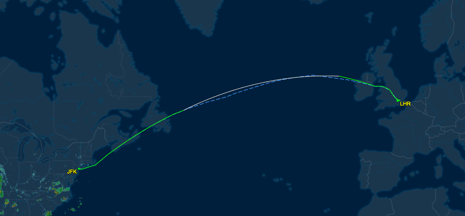
As the flight calls for crossing the Atlantic, the crew and dispatcher know that the plane will need to transit the Atlantic via the daily tracks published online, here. They are somewhat difficult to decipher, but we'll take a crack at Track V, below:
V ELSIR 53/50 54/40 55/30 55/20 RESNO NETKI EAST LVLS 320 330 340 350 360 370 380 390 400 WEST LVLS NIL EUR RTS EAST NIL NAR N319A N495C-
In the first line, we see that the "on-ramp in the sky" to Track V is at the waypoint ELSIR, which is about 100 miles off of the coast of Labrador, Newfoundland. The plane would have to fly there first from New York. The next points on the track are the degrees of latitude/longitude across the Atlantic. Finally, a few hours later we would expect to fly to the RESNO waypoint, which is off the coast of Ireland, and then exit the oceanic route at NETKI, just a bit closer to Ireland.
The second line indicates the eastbound flight levels that are available, which range from FL320 (or 32,000 feet) to FL400 (40,000 feet). This allows the pilots and dispatchers to choose a flight level with a stronger tailwind (on the way to the UK), or to climb as the aircraft burns fuel, which is lighter and can benefit from the thinner air up there.
The third and fourth lines indicate that there are no westbound flight levels or routes available. This makes sense: this track is one-way at the moment; no commercial aircraft are heading the opposite direction on these tracks. Aircraft obviously can fly back the other way, just not on these tracks.
The last line, N319A N495C indicate the preferred jet routes for aircraft to approach Track V and the ELSIR waypoint from wherever they may originate — in this case, JFK.
The flight plan is then loaded into the flight computer. It reads and looks more confusing than it actually is.
BETTE ACK BRADD N319A ELSIR NATV NETKI LIFFY Q37 MALUD Q38 NUGRA BNN1B
Let's decode this.
First, BETTE is a waypoint just off the coast of Long Island, our first en route waypoint after departure from JFK. ACK is the VOR radar station for Nantucket, and is our next "stop." BRADD is a waypoint off the coast of Nova Scotia, Canada. Then, the aircraft is to fly N319A, a jet route that takes it to the ELSIR waypoint. From there, the aircraft will hop on to the North Atlantic Track V as described above. Finally, it'll pop out on the other wide as described above.
After an uneventful flight, the aircraft's passengers will be at a pub in London in no time.
Mike Arnot is the founder of Boarding Pass NYC, a New York-based travel brand.
TPG featured card

at American Express's secure site
Terms & restrictions apply. See rates & fees.
| 4X | Earn 4X Membership Rewards® points per dollar spent on purchases at restaurants worldwide, on up to $50,000 in purchases per calendar year, then 1X points for the rest of the year. |
| 4X | Earn 4X Membership Rewards® points per dollar spent at US supermarkets, on up to $25,000 in purchases per calendar year, then 1X points for the rest of the year. |
| 5X | New! Earn 5X Membership Rewards® points on prepaid hotel stays booked through AmexTravel.com or the Amex Travel App. |
| 3X | Earn 3X Membership Rewards® points on flights booked through AmexTravel.com, the Amex Travel App, or purchased directly from airlines. |
| 2X | Earn 2X Membership Rewards® points on prepaid car rentals booked through AmexTravel.com or the Amex Travel App and cruises booked and paid through AmexTravel.com. |
| 1X | Earn 1X Membership Rewards® point per dollar spent on all other eligible purchases. |
Pros
- Valuable dining and food-related credits
- Flexible rewards with airline and hotel transfer partners
- Multiple travel and purchase protections
- No foreign transaction fees
- Access to Amex Offers for additional savings (enrollment required)
Cons
- Not as useful for those living outside the U.S.
- Some may have trouble using Uber and other dining credits
- You may be eligible for as high as 100,000 Membership Rewards® Points after you spend $8,000 in eligible purchases on your new Card in your first 6 months of Card Membership. Welcome offers vary and you may not be eligible for an offer. Apply to know if you’re approved and find out your exact welcome offer amount – all with no credit score impact. If you’re approved and choose to accept the Card, your score may be impacted.
- Earn 4X Membership Rewards® points per dollar spent on purchases at restaurants worldwide, on up to $50,000 in purchases per calendar year, then 1X points for the rest of the year.
- Earn 4X Membership Rewards® points per dollar spent at US supermarkets, on up to $25,000 in purchases per calendar year, then 1X points for the rest of the year.
- New! Earn 5X Membership Rewards® points on prepaid hotel stays booked through AmexTravel.com or the Amex Travel App.
- Earn 3X Membership Rewards® points on flights booked through AmexTravel.com, the Amex Travel App, or purchased directly from airlines.
- Earn 2X Membership Rewards® points on prepaid car rentals booked through AmexTravel.com or the Amex Travel App and cruises booked and paid through AmexTravel.com.
- Earn 1X Membership Rewards® point per dollar spent on all other eligible purchases.
- Pay It® lets you tap in the American Express® App to quickly pay for small purchase amounts throughout the month and still earn rewards the way you usually do. Plan It® gives you the option to split up big purchases into equal monthly payments with a fixed fee. You’ll know upfront exactly how much you’ll pay.
- Updated! $120 Dining Credit: Earn up to a total of $10 in statement credits monthly when you pay with the Gold Card at Grubhub (including Seamless), Buffalo Wild Wings, Five Guys, The Cheesecake Factory, and Wonder. This can be an annual savings of up to $120. Enrollment required.
- $100 Resy Credit: Get up to $100 in statement credits each calendar year at over 10,000 qualifying U.S. Resy restaurants after you pay for eligible purchases with the American Express® Gold Card. That’s up to $50 in statement credits semi-annually. Enrollment required.
- $84 Dunkin' Credit: Earn up to $7 in monthly statement credits after you pay with the American Express® Gold Card at U.S. Dunkin’ locations. Enrollment required.
- $120 Uber Cash on Gold: Enjoy up to $120 in Uber Cash annually with your Gold Card. Just add your Card to your Uber account and you'll get $10 in Uber Cash each month to use on orders and rides in the U.S. when you select an Amex Card for your transaction.
- New! As an American Express® Gold Card Member, you can enjoy complimentary Hertz Five Star® Status. Enjoy benefits like skipping the counter at select locations, adding an additional driver at no additional cost*, and vehicle upgrades**. Benefit enrollment and Hertz Gold+ registration are required. *Additional drivers must meet standard rental qualifications and must be a spouse or domestic partner to qualify as complimentary. Other additional drivers subject to fees. **Benefits are subject to availability and vary by location. Additional Hertz program Terms and Conditions including age restrictions apply.
- Take advantage of a $100 credit towards eligible charges* at over 1,300 upscale hotels worldwide when you book The Hotel Collection through AmexTravel.com or the Amex Travel App **. *Eligible charges vary by property. **The Hotel Collection requires a two-night minimum stay.
- Book your travel through the Amex Travel App with added peace of mind – backed by American Express® service and support. Only for American Express® Card Members.
- Whenever you need us, we're here. Our Member Services team will ensure you are taken care of. From lost Card replacement to statement questions, we are available to help 24/7.
- No Foreign Transaction Fees.
- Annual Fee is $325.
- Terms Apply.