Perfect landing: How pilots avoid colliding with the ground in tricky situations
As the old saying goes, "What goes up, must come down" and in aviation, the coming down part is statistically the most hazardous. From the very start of our training, pilots are taught to know where we are in relation to the terrain around us at all times.
We all love the views out of the window on a beautiful clear day, but how do we know where the terrain is on a nasty cloud-covered windy night?
Through layers of safety systems developed over the years of aviation, we are now better equipped than ever to reduce the risk of controlled flight into terrain -- CFIT. From accurate charts to GPS-based terrain avoidance systems, flying on a commercial airliner has never been safer.
How low can you go?
The key element to avoiding inadvertent contact with the ground is knowing where you are at all times. As pilots, not only do we have to be aware of what's around us in two dimensions, we also have to be conscious of what's around us in the third dimension -- above and below us.
Flying along on a lovely clear day, it's possible to see the ground below us and it's easy to identify hills and mountains. However, history has shown that even on days like this, CFIT accidents do still occur. As a result, no matter the weather conditions, we must always be aware of the height of the terrain around us.
However, just knowing the height of the closest mountain won't necessarily keep us safe. Many of the largest hills are home to radio masts and other telecoms structures which can be hundreds of feet high. As a result, we need to take these obstacles into consideration as well.
In addition to this, like with all things aviation, we also apply a safety margin. Adding all these together, we come up with a minimum safety altitude (MSA) -- the lowest altitude which we can fly that we know will keep us clear of the terrain.
Flight plan minimum safe altitude
As part of our printed paperwork, we always have a paper copy of the flight plan. Not only does this detail our route, but it also gives us the minimum safe altitude for that particular section of the route.
For aircraft like the 787 Dreamliner, due to the high accuracy from the GPS system, the flight plan takes the area five nautical miles either side of the route into consideration when calculating the MSA.

Read more: Can you hear me now: How pilots communicate with ATC while 35,000 feet in the air

At all times during the flight, even though we may appear relaxed whilst sipping a cup of coffee, we are always thinking "What if?". One of the biggest what-ifs is what would we do if we had a sudden loss of cabin pressurization.
Part of the procedure in this event is to "descend to 10,000 feet or MSA, whichever is highest." As a result, we need to constantly be aware of what that MSA is.
Minimum grid altitude (MGA)
Using the MSA is fine if we are flying on the flight planned route. However, quite often ATC gives a shortcut, which could take us outside the 10 nautical mile width of the flight plan MSA. In these situations, we need to update our MSA.
The MGA shows the lowest safe altitude which we can fly should we have to come off our flight planned route. This will also come into play when we've had to deviate off our route to avoid thunderstorms, or if we are diverting to another airport midflight.

The MGA is calculated by rounding up the elevation of the highest obstacle and adding on an increment of either:
- 2,000 feet for obstacles or terrain higher than 6,000 feet.
- 1,000 feet for obstacles or terrain 600 feet or lower.
On most charts, MGAs above 10,00 feet are shown in red for easy identification in the case of a rapid descent.
Minimum terrain clearance altitude (MTCA)
The MGA is deliberately a conservative number, designed to keep us safe when we may not be sure of our exact position on the chart. However, when descending into an airport, we are normally flying a standard terminal arrival route (STAR), which prescribes the exact route to be flown.
Therefore, if we are flying the route on the STAR, we know where we are in relation to the terrain so we can use a more accurate figure. This is the minimum terrain clearance altitude and is depicted on our charts in red, italicized writing.
Read more: How pilots adapt their takeoff plans at hot and high airports

By using the MTCA, we are able to safely descend to a lower altitude whilst flying on the STAR route, keeping us as close to the optimum descent profile as possible. Looking at the example above, even though the MGA between points SMASH and SALYY is 137 (13,700 feet), the MTCA when flying the STAR routing is a much lower 5,700 feet.
Minimum sector altitude (MSA)
The closer we get to landing, the lower our altitude becomes and so terrain clearance becomes even more critical. However, it's at this point where ATC tend to take us off a published approach procedure and vector us around the sky to fit us in with other aircraft.
As mentioned above, the MGA provides terrain information when flying off route but this is a very conservative figure. What we need when close to the airport is an accurate value and this is provided by the minimum sector altitude.

The MSA, (annoyingly the same acronym as minimum safe altitude) is based on a 25-nautical-mile circle around either the airfield or a navigation aid close by and ensures at least 1,000 feet clearance from any obstacle within that area.
When approaching Los Angeles, the surrounding mountains give an MGA of 10,100 feet. Far from ideal when we're trying to get low enough to land. However, the runway approach chart depicts a 25-nautical-mile circle around the LAX navigation beacon. From this, we can see that the MSA in the area of the approach is actually 2,700 feet.
Adjusting minimum safe altitude due to weather
Once we have decided on the most appropriate MSA for our position, it's still not time to relax and put our feet up. The weather can have an effect on our flying conditions, so we need to take this into consideration before coming up with the MSA that we're going to use.
Strong winds
When flying over mountainous terrain, strong winds can cause severe turbulence. Whilst the turbulence itself is not a threat to the aircraft, the combination of the already-high MSA and altitude deviations from the turbulence could cause problems.
As a result, when winds are greater than 60 knots, we increase our MSA by 2,000 feet.
Cold temperatures
The air temperature affects the air density -- the colder the air, the denser it is. Whilst this brings performance benefits on takeoff, it provides a potential trap during the descent.
Very cold temperatures cause the altimeter, the cockpit instrument telling us our altitude, to overread. This results in us flying lower than we actually think we are. As a result, we must also consider adjusting our MSA to ensure that we stay sufficiently clear of terrain.
Vertical situation display
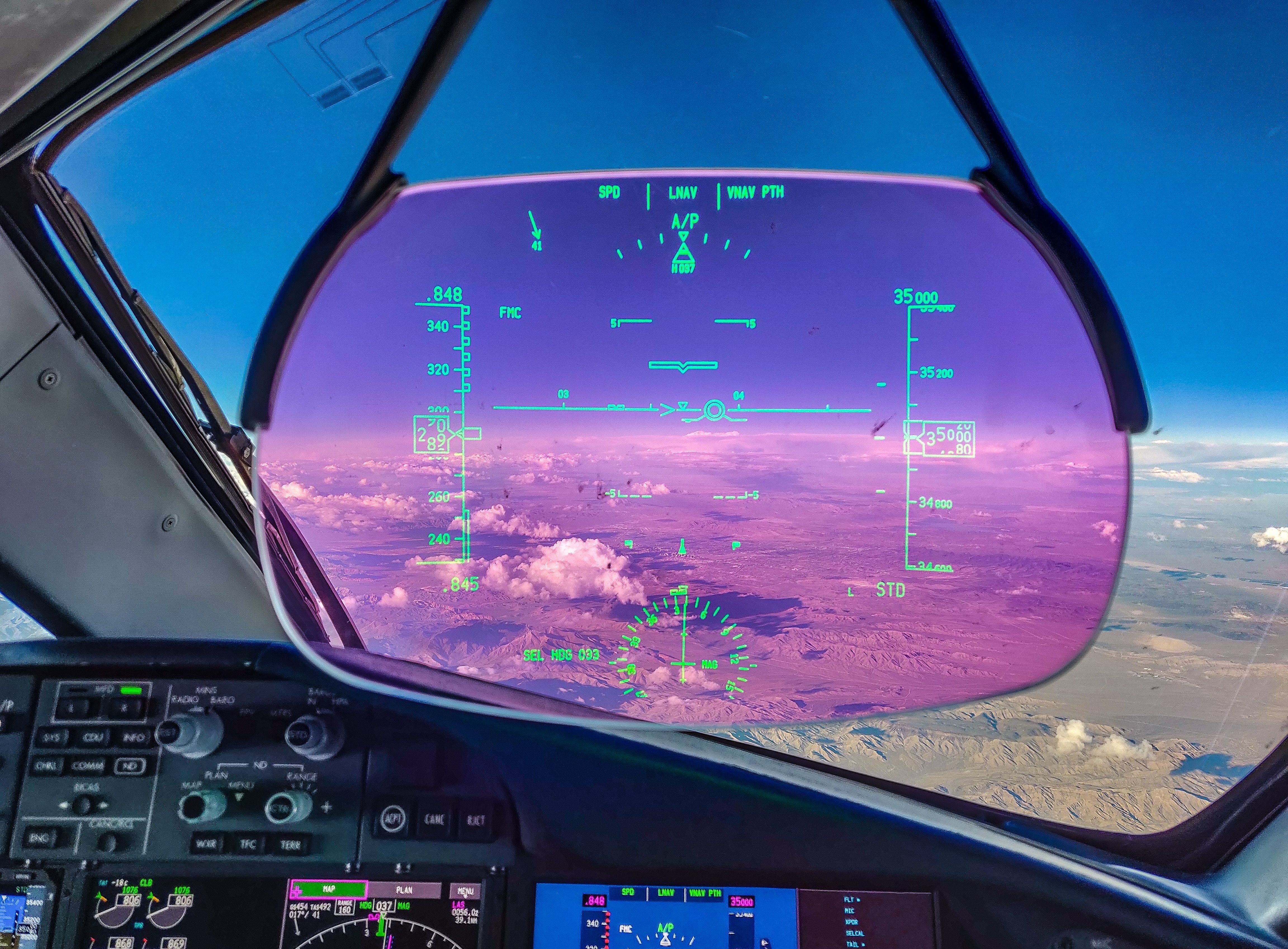
For years, aircraft have had a map display, showing pilots waypoints, airports and weather systems hundreds of miles ahead. These are even able to show areas of high terrain with different color shading. However, the limitation of this kind of display is that it can only depict data in the horizontal plane.
Read more: The maneuvers pilots use to prevent a collision in the air

Modern aircraft such as the 787 Dreamliner now incorporate a vertical situation display (VSD) to show pilots where the aircraft is in relation to the surrounding terrain. Not only does it show us where we are now, but it also depicts our future flight path depending on our planned descent and our actual descent.
With a quick glance, we are able to see if our current path will conflict with the terrain and take early steps to rectify the issue.
Escape routes
For the majority of a given flight, the MSA stays below 10,000 feet so is there is no problem should we need to perform a rapid descent in the case of losing cabin pressurization. However, crossing some mountain ranges, such as the Andes in South America, can generate MSAs as high as 23,000 feet. This can cause a problem in not only the loss of pressurization case but also in the case of an engine failure.
Most aircraft have enough oxygen to supply the masks in the cabin for 15 to 20 minutes. This is more than enough time in the case of a normal rapid descent. However, when crossing range like the Andes, our planned route may not enable us to descend to an altitude where the mask is not required quickly enough.
In the engine failure scenario, as much as an aircraft like the 787 can fly safely on a single engine, it is often too heavy to maintain the cruising altitude. As a result, we must descend to a lower level. The heavier the aircraft is, the lower that lower level must be.
It gets to a point where this lower altitude, know as the drift down altitude, may be lower than the MSA, which gives us a problem.
In both cases, to enable us to rapidly descend down to the required lower altitude, airlines' operations department calculates escape routes that we use to get away from the worst of the terrain as quickly as possible.
These will dictate the initial altitude to descend to whilst making a turn off the route. This is either back toward where we've come from or turning perpendicular to our track and taking the most direct route toward lower ground.
Once clear of the terrain, we can then descend down to the lower altitude as required for the rapid descent or drift down.
GPWS
However, even with the protection of all of the above, on rare occasions, pilots find themselves in a situation where there is a real chance of colliding with the ground. In this scenario, there is a final safety net onboard commercial aircraft.
The enhanced ground proximity warning system is an automated system which uses the aircraft's GPS position and an onboard terrain database to warn pilots of an imminent collision with the ground.
Depending on the severity of the EGPWS alert, pilots must either change the rate of descent of the aircraft or perform a full "pull up" maneuver.
Since the introduction of EGPWS in commercial airliners, there has not been a single fatality when pilots responded correctly to the activation of the system.
Bottom line
An inadvertent collision with the ground rarely ends well for aircraft and pilots. As a result, ensuring that we are aware of our surroundings at all times is drilled into us from day one of flight school. As most CFIT accidents occur on the approach to landing, we pay particular attention to the threat of terrain when conducting our descent brief.
We use various sources of information to conclude what is the most relevant MSA for a particular stage of flight. Any descent below this altitude must be verbalized and justified by both pilots. If any doubt exists about the aircraft's position in relation to the terrain, an immediate climb to the MSA must be performed.
Even if pilots lose their situational awareness, there is one last line of defense to prevent an accident. The EGPWS alerts pilots to an impending ground collision, giving us time to react and escape the situation. I'll be delving deeper into how the EGPWS works next week.
TPG featured card

at American Express's secure site
Terms & restrictions apply. See rates & fees.
| 4X | Earn 4X Membership Rewards® points per dollar spent on purchases at restaurants worldwide, on up to $50,000 in purchases per calendar year, then 1X points for the rest of the year. |
| 4X | Earn 4X Membership Rewards® points per dollar spent at US supermarkets, on up to $25,000 in purchases per calendar year, then 1X points for the rest of the year. |
| 5X | New! Earn 5X Membership Rewards® points on prepaid hotel stays booked through AmexTravel.com or the Amex Travel App. |
| 3X | Earn 3X Membership Rewards® points on flights booked through AmexTravel.com, the Amex Travel App, or purchased directly from airlines. |
| 2X | Earn 2X Membership Rewards® points on prepaid car rentals booked through AmexTravel.com or the Amex Travel App and cruises booked and paid through AmexTravel.com. |
| 1X | Earn 1X Membership Rewards® point per dollar spent on all other eligible purchases. |
Pros
- Valuable dining and food-related credits
- Flexible rewards with airline and hotel transfer partners
- Multiple travel and purchase protections
- No foreign transaction fees
- Access to Amex Offers for additional savings (enrollment required)
Cons
- Not as useful for those living outside the U.S.
- Some may have trouble using Uber and other dining credits
- You may be eligible for as high as 100,000 Membership Rewards® Points after you spend $8,000 in eligible purchases on your new Card in your first 6 months of Card Membership. Welcome offers vary and you may not be eligible for an offer. Apply to know if you’re approved and find out your exact welcome offer amount – all with no credit score impact. If you’re approved and choose to accept the Card, your score may be impacted.
- Earn 4X Membership Rewards® points per dollar spent on purchases at restaurants worldwide, on up to $50,000 in purchases per calendar year, then 1X points for the rest of the year.
- Earn 4X Membership Rewards® points per dollar spent at US supermarkets, on up to $25,000 in purchases per calendar year, then 1X points for the rest of the year.
- New! Earn 5X Membership Rewards® points on prepaid hotel stays booked through AmexTravel.com or the Amex Travel App.
- Earn 3X Membership Rewards® points on flights booked through AmexTravel.com, the Amex Travel App, or purchased directly from airlines.
- Earn 2X Membership Rewards® points on prepaid car rentals booked through AmexTravel.com or the Amex Travel App and cruises booked and paid through AmexTravel.com.
- Earn 1X Membership Rewards® point per dollar spent on all other eligible purchases.
- Pay It® lets you tap in the American Express® App to quickly pay for small purchase amounts throughout the month and still earn rewards the way you usually do. Plan It® gives you the option to split up big purchases into equal monthly payments with a fixed fee. You’ll know upfront exactly how much you’ll pay.
- Updated! $120 Dining Credit: Earn up to a total of $10 in statement credits monthly when you pay with the Gold Card at Grubhub (including Seamless), Buffalo Wild Wings, Five Guys, The Cheesecake Factory, and Wonder. This can be an annual savings of up to $120. Enrollment required.
- $100 Resy Credit: Get up to $100 in statement credits each calendar year at over 10,000 qualifying U.S. Resy restaurants after you pay for eligible purchases with the American Express® Gold Card. That’s up to $50 in statement credits semi-annually. Enrollment required.
- $84 Dunkin' Credit: Earn up to $7 in monthly statement credits after you pay with the American Express® Gold Card at U.S. Dunkin’ locations. Enrollment required.
- $120 Uber Cash on Gold: Enjoy up to $120 in Uber Cash annually with your Gold Card. Just add your Card to your Uber account and you'll get $10 in Uber Cash each month to use on orders and rides in the U.S. when you select an Amex Card for your transaction.
- New! As an American Express® Gold Card Member, you can enjoy complimentary Hertz Five Star® Status. Enjoy benefits like skipping the counter at select locations, adding an additional driver at no additional cost*, and vehicle upgrades**. Benefit enrollment and Hertz Gold+ registration are required. *Additional drivers must meet standard rental qualifications and must be a spouse or domestic partner to qualify as complimentary. Other additional drivers subject to fees. **Benefits are subject to availability and vary by location. Additional Hertz program Terms and Conditions including age restrictions apply.
- Take advantage of a $100 credit towards eligible charges* at over 1,300 upscale hotels worldwide when you book The Hotel Collection through AmexTravel.com or the Amex Travel App **. *Eligible charges vary by property. **The Hotel Collection requires a two-night minimum stay.
- Book your travel through the Amex Travel App with added peace of mind – backed by American Express® service and support. Only for American Express® Card Members.
- Whenever you need us, we're here. Our Member Services team will ensure you are taken care of. From lost Card replacement to statement questions, we are available to help 24/7.
- No Foreign Transaction Fees.
- Annual Fee is $325.
- Terms Apply.