Hopping Across the Pond: How Pilots Find Their Way to the USA
The route between London and New York is the busiest in the world, with more than 30 flights a day in each direction. Airlines such as Virgin Atlantic, British Airways, American Airlines, United Airlines, Delta Air Lines and Norwegian fly a variety of aircraft types between the two cities. But how do they find their way between the two? Is it a matter of getting airborne out of London and just flying west?
In my article last week, I explained how pilots navigate from one airport to another. This is all done under the watchful eye of Air Traffic Control (ATC). Using the all-seeing eye of radar, controllers can monitor aircraft as they fly down a series of motorways in the skies. These airways are defined by a combination of navigation beacons and virtual GPS waypoints. These create a network of routes that crisscross the skies above your head, taking the aircraft to their destination.

But there is a limitation with radar in that it only has a range of a few hundred miles. What then happens when aircraft head out over the Atlantic? How are they kept safely separated from each other? How do they know where they're going? For every problem, aviation has a solution.
The North Atlantic Organized Track System
With more than 2,000 flights crossing the Atlantic every day, without a plan, the whole thing would quickly descend into chaos. Aircraft need to go from A to B as safely as possible but also as commercially efficient as possible. For the most part, traffic heading east from North America to Europe does so overnight. A few hours later, the flow is reversed as the aircraft make their way back to the US and Canada.
80% of traffic crossing the pond passes through the Shanwick Oceanic Area Control Centre (OACC), as seen in the video above. Based in Prestwick, Scotland, controllers have the responsibility of receiving traffic off the Atlantic in the early hours and then sending them back across a few hours later. In order to facilitate this flow, each night, airlines send Shanwick their preferred routings for their westbound flights that coming day. Controllers collate this data and create a set of routes using GPS positions, the Organized Track System (OTS). There are usually around six to seven of these routes each day. These tracks are then given a designator, labeled Alpha, Bravo, Charlie, etc. Any flights planning to fly in this area must use the OTS.
Supply vs. Demand
If you read my article on how pilots decide how high they fly, you'll know that for the most part, pilots obey the semi circular rule. Flights heading west fly at even levels and those heading east fly at odd levels. Bearing in mind most aircraft will want to fly between 31,000 feet and 39,000 feet, this presents a problem. In theory, there will only be four levels available to westbound traffic — 32,000, 34,000, 36,000 and 38,000 feet. However, this is where the beauty of the tracks comes in.

Because all aircraft wishing to travel in this part of the Atlantic have to fly the tracks, it means that there is no eastbound traffic. Remember, the daytime tracks are for westbound flights only. As a result, the levels that would normally be used for eastbound flights can be utilized, increasing the levels available from four up to nine. This is, in effect, the same as if the M1 allowed traffic to use both sides of the carriage way to go in the same direction at certain times of the day.
Whilst aircraft are separated vertically, they also have to be separated laterally. In order to do this, flights are sequenced to arrive at their track in 10-minute intervals. Once on the track, they then fly at a set speed to ensure that the gap is maintained from aircraft ahead and behind.

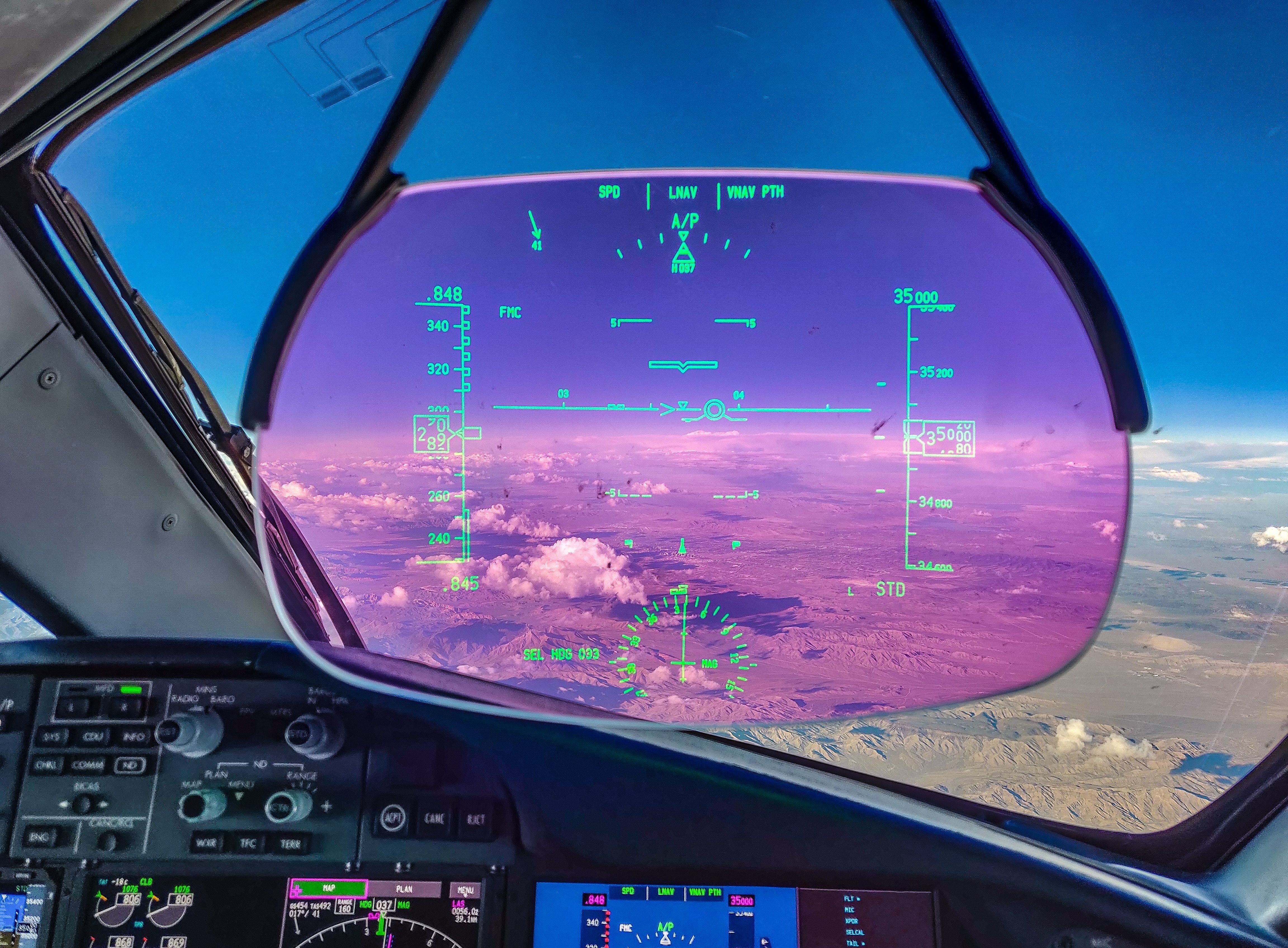
So that's how the system works in theory. But how does it work in practice? Do pilots have to do anything special or do they just rock up and head down their track at their discretion. Let's take the example of the flight shown in the photo, a 787 Dreamliner flying from London Heathrow to New York's JFK airport.
The Pilot's Perspective
As mentioned previously, when the pilots report for duty, they print out their flight paperwork for the day. This shows them the route that the planning department have decided that they're going to use, including their oceanic track. This takes into consideration a number of factors to give the most cost- and time-effective path. Part of this flight plan also includes information about the OTS of the day.
The Track Message Indicator (TMI) details the tracks available for the day, including the levels available. As the position of the tracks changes daily, it is important for pilots to confirm that the TMI is correct for the date and time of their flight. The TMI details the entry point of the track, the route and the exit point.

Once airborne out of Heathrow, one of the pilots contacts the controllers at the Shanwick OACC. This can either be done over the radio, or, more commonly, by CPDLC — Controller-Pilot Data Link Communications. I'll be exploring this in more detail in a future article, but for now, let's just describe it as a form of text messaging between the pilots and the controllers. The controller will already have the filed plan so they just need some updated information from the crew. The pilot passes the estimated time at the entry point, the level requested and the speed at which they'd like to fly. The controller takes this data and collates it with all the other aircraft heading from Europe toward North America.
Jostling for Position
With a set number of tracks and levels, there's often competition for space. It's not uncommon for two flights to be planned on the same track and to request the same level at the same time. If this happens, ATC has a few options. Firstly, if the two competing aircraft aren't far off their 10-minute gap, the controller may try to rectify this before they reach the track. By telling the trailing aircraft not to reach the entry point before a certain time, the required spacing can be created.
If increasing the gap isn't feasible, the next option is for one aircraft to fly a level different to what they requested. This can have implications for their fuel consumption, which is why all aircraft carry extra fuel.
The third option is to send the aircraft on a different track. This is the least-preferred option, as it involves a lot of work for the pilots and has the potential to lead to navigational errors. When the route is changed, however, the crew must follow strict procedures to ensure that the aircraft is flying the new route accurately.
The Oceanic Clearance
Once the controllers have their plan in place, they send the instructions to the pilots in the form of an Oceanic Clearance, once again, normally by CPDLC. This confirms the route, the level and the speed at which they must fly. If there are any changes to these parameters, it's contained within this message.

As there is no radar coverage over the Atlantic, it's critical that the aircraft flies exactly what it has been cleared to do. Both pilots independently check the route, speed and level against the clearance. The Autopilot is only as good as the information the pilots give it. If the route loaded in the flight computer is wrong, the aircraft will fly that incorrect route.
Oceanic Entry Point
As a passenger, once you're onto your second G & T, eagerly awaiting the arrival of your in-flight meal, the aircraft is rapidly approaching its Oceanic Entry Point. In the flight deck, the pilots are making one final check of the route, ensuring that they are now at the level and speed required for the crossing. They discuss what they would do should they need to leave the tracks and divert to another airport. This could be due to a technical problem or, as is more likely, a medical problem with a passenger.

Transatlantic Comms
Like radar, the range of normal voice communications is limited to a few hundred miles. As the Very High Frequency (VHF) radio waves travel in a straight line, the curve of the earth becomes an impediment. The earth literally gets in the way of transmissions being sent from aircraft.
Traditionally, oceanic communications relied on High Frequency (HF) radio communications. These don't require line of sight for a connection as they use the earth's upper atmosphere to bounce back down. However, these are notoriously unreliable as they are affected by the earth's magnetic field and can quite often be unusable. As a result, HF comms are mostly used as a backup.
The advent of satellites in orbit above the earth solved this problem. By using satellite communications, the CPDLC system can keep the pilots in contact with the controllers on the ground in Prestwick.
Each time the aircraft crosses a waypoint on the track, the communications system automatically sends a position report to the controllers on the ground. This enables them to know what time the aircraft passed that point and at what altitude. It also tells them at what time they estimate the next waypoint. In the absence of radar, these position reports enable controllers to keep tabs on aircraft and ensure they remain safely separated.
As you may have noticed in the video at the top, the Shanwick controllers are only responsible for the eastern half of the Atlantic. At 30° of longitude West, aircraft are transferred to the responsibility of Gander OACC, based in Gander, Canada. Approaching "thirty west," aircraft log off the Shanwick CPDLC and connect to the Gander CPDLC. Pilots are also given a set of HF frequencies as their backup communications. Once connected with Gander, the flight proceeds as before, with the aircraft now sending position reports to Canada instead of Scotland.
As the flight approaches its oceanic exit point, it is transferred to controllers at Gander Domestic. Here, back under radar and VHF radio range, the aircraft has to be integrated into the domestic traffic flow and this means obeying the semicircular rule again. Aircraft flying at odd levels will be asked which even level they would prefer, before climbing or descending to that level. Once off the track, pilots are then able to return to their preferred speed, if different to the oceanic clearance.
Bottom Line
From here, aircraft are once again subject to the same controlling and communications as when leaving London. Gander Control becomes Moncton, which then hands the flight over to Boston Control and then finally New York for the early evening arrival. Just another of the hundreds of flights that cross the Atlantic every day.
However, whilst the aircraft has been airborne, preparations are already well under way for the return leg, which works almost identically. Flight planners have already filed the flight plan, the passengers are checking in and the crew are getting ready to leave the New York hotel. It won't be long before the overnight eastbound flow to Europe begins, just another cycle in this nonstop world.
TPG featured card

at American Express's secure site
Terms & restrictions apply. See rates & fees.
| 4X | Earn 4X Membership Rewards® points per dollar spent on purchases at restaurants worldwide, on up to $50,000 in purchases per calendar year, then 1X points for the rest of the year. |
| 4X | Earn 4X Membership Rewards® points per dollar spent at US supermarkets, on up to $25,000 in purchases per calendar year, then 1X points for the rest of the year. |
| 5X | New! Earn 5X Membership Rewards® points on prepaid hotel stays booked through AmexTravel.com or the Amex Travel App. |
| 3X | Earn 3X Membership Rewards® points on flights booked through AmexTravel.com, the Amex Travel App, or purchased directly from airlines. |
| 2X | Earn 2X Membership Rewards® points on prepaid car rentals booked through AmexTravel.com or the Amex Travel App and cruises booked and paid through AmexTravel.com. |
| 1X | Earn 1X Membership Rewards® point per dollar spent on all other eligible purchases. |
Pros
- Valuable dining and food-related credits
- Flexible rewards with airline and hotel transfer partners
- Multiple travel and purchase protections
- No foreign transaction fees
- Access to Amex Offers for additional savings (enrollment required)
Cons
- Not as useful for those living outside the U.S.
- Some may have trouble using Uber and other dining credits
- You may be eligible for as high as 100,000 Membership Rewards® Points after you spend $8,000 in eligible purchases on your new Card in your first 6 months of Card Membership. Welcome offers vary and you may not be eligible for an offer. Apply to know if you’re approved and find out your exact welcome offer amount – all with no credit score impact. If you’re approved and choose to accept the Card, your score may be impacted.
- Earn 4X Membership Rewards® points per dollar spent on purchases at restaurants worldwide, on up to $50,000 in purchases per calendar year, then 1X points for the rest of the year.
- Earn 4X Membership Rewards® points per dollar spent at US supermarkets, on up to $25,000 in purchases per calendar year, then 1X points for the rest of the year.
- New! Earn 5X Membership Rewards® points on prepaid hotel stays booked through AmexTravel.com or the Amex Travel App.
- Earn 3X Membership Rewards® points on flights booked through AmexTravel.com, the Amex Travel App, or purchased directly from airlines.
- Earn 2X Membership Rewards® points on prepaid car rentals booked through AmexTravel.com or the Amex Travel App and cruises booked and paid through AmexTravel.com.
- Earn 1X Membership Rewards® point per dollar spent on all other eligible purchases.
- Pay It® lets you tap in the American Express® App to quickly pay for small purchase amounts throughout the month and still earn rewards the way you usually do. Plan It® gives you the option to split up big purchases into equal monthly payments with a fixed fee. You’ll know upfront exactly how much you’ll pay.
- Updated! $120 Dining Credit: Earn up to a total of $10 in statement credits monthly when you pay with the Gold Card at Grubhub (including Seamless), Buffalo Wild Wings, Five Guys, The Cheesecake Factory, and Wonder. This can be an annual savings of up to $120. Enrollment required.
- $100 Resy Credit: Get up to $100 in statement credits each calendar year at over 10,000 qualifying U.S. Resy restaurants after you pay for eligible purchases with the American Express® Gold Card. That’s up to $50 in statement credits semi-annually. Enrollment required.
- $84 Dunkin' Credit: Earn up to $7 in monthly statement credits after you pay with the American Express® Gold Card at U.S. Dunkin’ locations. Enrollment required.
- $120 Uber Cash on Gold: Enjoy up to $120 in Uber Cash annually with your Gold Card. Just add your Card to your Uber account and you'll get $10 in Uber Cash each month to use on orders and rides in the U.S. when you select an Amex Card for your transaction.
- New! As an American Express® Gold Card Member, you can enjoy complimentary Hertz Five Star® Status. Enjoy benefits like skipping the counter at select locations, adding an additional driver at no additional cost*, and vehicle upgrades**. Benefit enrollment and Hertz Gold+ registration are required. *Additional drivers must meet standard rental qualifications and must be a spouse or domestic partner to qualify as complimentary. Other additional drivers subject to fees. **Benefits are subject to availability and vary by location. Additional Hertz program Terms and Conditions including age restrictions apply.
- Take advantage of a $100 credit towards eligible charges* at over 1,300 upscale hotels worldwide when you book The Hotel Collection through AmexTravel.com or the Amex Travel App **. *Eligible charges vary by property. **The Hotel Collection requires a two-night minimum stay.
- Book your travel through the Amex Travel App with added peace of mind – backed by American Express® service and support. Only for American Express® Card Members.
- Whenever you need us, we're here. Our Member Services team will ensure you are taken care of. From lost Card replacement to statement questions, we are available to help 24/7.
- No Foreign Transaction Fees.
- Annual Fee is $325.
- Terms Apply.