Runway approaching: How pilots find their way safely to the ground in all elements

Flying halfway around the world is great, but unless you can accurately find your for way those last few hundred feet to the runway, it's all a bit pointless. When the weather is good, pilots are able to see the airport from several miles away. However, what do we do when there is low cloud or snow reducing the visibility? Fortunately, most airfields have some sort of approach system in place which enables us to safely descend the aircraft toward the runway. This is how we do it.
What stops pilots from making an approach?
For every approach to a runway, there is minimum weather criteria which pilots must legally abide by. This is to ensure the safety of the aircraft and to prevent pilots from "chancing it" in the hope that they might still be able to land.
This criteria varies from approach to approach, runway to runway and aircraft to aircraft. There are two elements to the approach: the visibility and the Minimum Descent Altitude (MDA)/ Decision Altitude (DA). These values are published at the bottom of the relevant approach chart which is available to the pilots.
Sign up for the free daily TPG newsletter for more travel tips!

The visibility is the defining factor, the legal limit dictating whether or not we can start the approach. If the visibility reported by the airfield is below the minimal on the chart, we are not allowed to start the approach. It's that black and white.
The MDA/DA is the altitude down to which we are allowed to fly the aircraft before having to make a decision. If at that point we can see the runway, we can continue to land. If not, we must perform a go-round and head back up into the sky.
If the reported visibility is good enough but the cloud base is lower than the MDA/DA, we can still start an approach. However, we will do so knowing that there is a very high chance of not seeing the runway at the decision point and having to turn round.
Read more: Behind the scenes: What goes on in the flight deck during a diversion?

What was used in the past — VOR/NDB
A Very High Frequency Omni-Directional Range (VOR) is a type of short-range radio navigation beacon which emits a signal. Aircraft fitted with the right equipment are able to pick up this signal and not only determine where the beacon is, but also how far they are from it. The distance is quantified as Distance Measuring Equipment — DME.
VORs have been around for quite a while and were first developed in the 1930s, entering service in the mid 1940s. The best feature of VORs over older types of navigation beacons are that the signal is true and strong. Older types were subject to interference from the atmosphere and would only provide direction, not distance.

As the signal emitted by VORs are sent in a straight line, they are limited by the line of sight — they continue into space as the earth curves away beneath them. As a result, for an aircraft in the cruise, they are only useful within around 140 miles. However, this range is enough to enable aircraft to fly one from beacon to another as they zigzag their way around the world.
Where VORs became very useful was in the final stages of approach when there is low cloud.
By placing a VOR at or near an airfield, pilots are able to fly toward the beacon from a certain direction and be fairly confident of their position. Then, using the DME to determine how far they are from the beacon, pilots can then start to descend toward the airfield.
A good advantage of a VOR is that the approach doesn't have to be straight toward the runway. At airfields where there are hills on the extended centerline of the runway, pilots can fly toward the airfield at an angle which keeps them clear of the terrain. Once out of the cloud and with the runway in sight, they can then turn the aircraft to line up with the runway.
VOR approaches tend to be found at smaller airports where the facilities are limited. They're quite common at the airports around the Greek islands.

There is, however, one main draw back to VOR approaches and that's the accuracy.
When flying around the earth at 36,000 feet, being a mile or two off track isn't a major issue. However, when you're trying to thread your way between hills on the approach to land, accuracy is everything. As a result, the minima on VOR approaches tends to be very conservative. It's not uncommon to require several thousand meters of visibility to start the approach and have an MDA of around 600 feet, or higher, above the ground.
This is fine when the weather is decent, but no good when proper winter weather sets in. What you need is something more robust which will allow pilots to fly lower in worse visibility.
What's used now — ILS
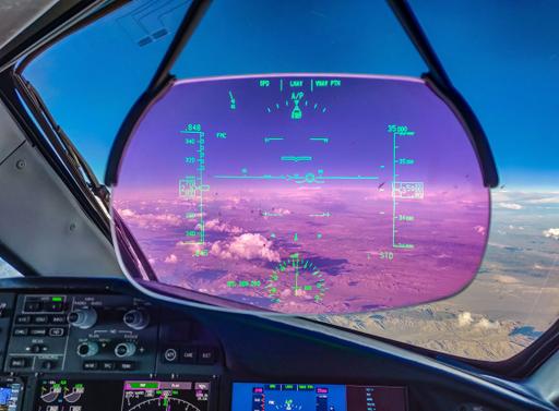
Fly into any major international airport and I'd be confident in saying that you flew an ILS — Instrument Landing System — approach. Developed to give greater accuracy when approaching the runway, the best ILS approaches allow pilots to fly their aircraft all the way to runway, without even needing to see the ground outside.
The ILS consists of two radio beams which project up from the area around the runway up into the approach path. These signals are then picked up in the aircraft by the ILS receiver which displays them on the screens in the flight deck.
The first signal is the localizer, radiating from antennae which sit at the end of the runway. This shows the pilots where the aircraft is in relation to the centerline. The second signal comes from antennae to the side of the runway, around 1,000 feet in from the threshold abeam the touchdown zone. This is the glideslope and it sends another beam into the sky, normally at an angle of three degrees to guide the aircraft down vertically to the correct touchdown spot.
Most ILS approaches are flown with the Autopilot doing the flying and the pilots monitoring the systems. When the required visual references are seen, the pilot flying will disconnect the Autopilot and land the aircraft manually.
Cat I ILS
In its most basic form, a Category One (CAT I) ILS allows aircraft to start an approach with just 550 meter reported visibility and a DA of 200 feet above the ground. This will normally suffice in 99% of weather conditions an airfield will experience in a year. As a result, CAT I ILS approaches are found at all major international airports and are the default type of used.
That said, some airports are so busy that should conditions be worse than 550 meter visibility, the whole flying operation would have to shut down. In order to deal with these situations, there are other kinds of ILS approaches available.

CAT II ILS
When the weather really closes in, the standard method of reporting visibility isn't quite good enough. In order to give more accurate readings of the visibility, a special device called a transmissometer measures the Runway Visual Range — RVR.
In its simplest form, the transmissometer fires a light source between an emitter and a sensor. This interaction measures the "thickness" of moisture in the air and gives the RVR in meters.
A CAT II approach uses the same ILS signal from the localizer and glideslope, but there are added protections in place to preserve the integrity of the ILS beams. In addition with a CAT II approach, instead of using the pressure-based altimeter (fairly accurate) to descend to the DA, pilots use the Radio Altimeter (very accurate) to fly to a Decision Height (DH). The radio altimeter shoots a radar beam down beneath the aircraft to give an exact height the aircraft is above the ground.
As a result of the increased accuracy, CAT II approaches have a lower minima, normally around 300 meter RVR with a DA of 100 feet above the ground. These reduced minima also mean that the pilots normally leave the Autopilot engaged till touchdown and perform an autoland. That said, should there be a failure in either the ground or aircraft-based systems, there are enough visual references out of the window for the pilots to still land manually.
Read more: How pilots stay alert on ultra-long-range flights
CAT IIIA and CAT IIIB ILS
When things get really foggy, the ultimate in navigational accuracy is required. With a CAT III approach, aircraft can land with a RVR of just 75 meters and with no DH — in effect having no need to see anything out of the window before landing. Needless to say that CAT III approaches are always autolands.
With a CAT IIIB approach, there are enough redundancies in the system to still land with a 75-meter RVR in the case of a system failure. In a CAT IIIB approach, certain failures would require the pilots to revert to using the CAT II minima. If this happened late on in the approach, it may well require a go-round. This is exactly why bad weather landings are carried out by the Autopilot — it gives the pilots the spare capacity to notice system failures and take the appropriate actions when time is tight.

The future — RNAV and GPS
ILS systems are great as they give unparalleled accuracy, but their major flaw is that the approach has to be directly lined up with the runway. This is fine for places like Dubai, where the area around the airport is flat, but not great for places surrounded by hills.
For these places, VOR approaches always used to be the only method of making approaches in cloud but with the advance of GPS technology, a whole new method of approaches has been born — RNAV approaches.
In its basic form, RNAV approaches allow aircraft to use the accuracy of their systems on board to make an approach into an airfield which has no physical antennae on the ground. This means that, in theory, an aircraft can make an approach into any airport in the world with the correct authorization.
RNAV approaches
RNAV approaches use a series of GPS waypoints to guide the pilots laterally toward the runway. So long as the systems on board the aircraft can maintain the required accuracy (normally 0.3 miles), the pilots can then also descend in accordance with the profile published on the approach charts.
This is ideal for smaller airports as they don't have to pay for and continue to maintain expensive ILS systems on the ground. Once the approach has been created and authorized by the relevant authorities, pilots can just fly the published approach using their equipment on board.
However, when RNAV approaches really come into their own is when there is terrain around.
AR (Authorization Required) approaches
The crème de la crème of airfield approaches, RNAV AR approaches, allow pilots to fly their aircraft around the tightest of terrain and still line up with the runway. Whilst the approach is published for all to see, the AR aspect means that each airline must receive approval from the regulator in order to fly that specific approach. This will normally involve training in the simulator for all pilots before the approval is granted.
While the minima isn't normally much better than a VOR or normal RNAV approach, the increased accuracy of an AR approach enables aircraft to land into places which they would normally be unable to do so. A great example of this is into Innsbruck (INN) in Austria, as seen in the chart below.

With the approach starting at the western end of the valley, the pilots instruct the Autopilot to fly the aircraft to fly via the prescribed waypoints, turning down the valley, descending as they go. Whilst the required visibility is 2,400 meters, the approach brings the aircraft safely down to just 1,000 feet above the airfield.
Bottom line
Getting the aircraft safely onto the runway at the destination is the primary task of your pilots. In order to do so, there are a number of different approaches which we could be expected to fly, depending on the facilities available at the airfield.
VOR approaches were groundbreaking for their time, but as technology progressed, more accurate systems became available. ILS approaches are the norm for most major airports now, allowing aircraft to land in just 75-meter visibility. However, with increased accuracy and reliability of GPS, RNAV approaches are becoming more common. They allow aircraft to make approaches into airfields where previously they were unable, all without the added cost of ground based navigation systems.
TPG featured card

at American Express's secure site
Terms & restrictions apply. See rates & fees.
| 4X | Earn 4X Membership Rewards® points per dollar spent on purchases at restaurants worldwide, on up to $50,000 in purchases per calendar year, then 1X points for the rest of the year. |
| 4X | Earn 4X Membership Rewards® points per dollar spent at US supermarkets, on up to $25,000 in purchases per calendar year, then 1X points for the rest of the year. |
| 5X | New! Earn 5X Membership Rewards® points on prepaid hotel stays booked through AmexTravel.com or the Amex Travel App. |
| 3X | Earn 3X Membership Rewards® points on flights booked through AmexTravel.com, the Amex Travel App, or purchased directly from airlines. |
| 2X | Earn 2X Membership Rewards® points on prepaid car rentals booked through AmexTravel.com or the Amex Travel App and cruises booked and paid through AmexTravel.com. |
| 1X | Earn 1X Membership Rewards® point per dollar spent on all other eligible purchases. |
Pros
- Valuable dining and food-related credits
- Flexible rewards with airline and hotel transfer partners
- Multiple travel and purchase protections
- No foreign transaction fees
- Access to Amex Offers for additional savings (enrollment required)
Cons
- Not as useful for those living outside the U.S.
- Some may have trouble using Uber and other dining credits
- You may be eligible for as high as 100,000 Membership Rewards® Points after you spend $8,000 in eligible purchases on your new Card in your first 6 months of Card Membership. Welcome offers vary and you may not be eligible for an offer. Apply to know if you’re approved and find out your exact welcome offer amount – all with no credit score impact. If you’re approved and choose to accept the Card, your score may be impacted.
- Earn 4X Membership Rewards® points per dollar spent on purchases at restaurants worldwide, on up to $50,000 in purchases per calendar year, then 1X points for the rest of the year.
- Earn 4X Membership Rewards® points per dollar spent at US supermarkets, on up to $25,000 in purchases per calendar year, then 1X points for the rest of the year.
- New! Earn 5X Membership Rewards® points on prepaid hotel stays booked through AmexTravel.com or the Amex Travel App.
- Earn 3X Membership Rewards® points on flights booked through AmexTravel.com, the Amex Travel App, or purchased directly from airlines.
- Earn 2X Membership Rewards® points on prepaid car rentals booked through AmexTravel.com or the Amex Travel App and cruises booked and paid through AmexTravel.com.
- Earn 1X Membership Rewards® point per dollar spent on all other eligible purchases.
- Pay It® lets you tap in the American Express® App to quickly pay for small purchase amounts throughout the month and still earn rewards the way you usually do. Plan It® gives you the option to split up big purchases into equal monthly payments with a fixed fee. You’ll know upfront exactly how much you’ll pay.
- Updated! $120 Dining Credit: Earn up to a total of $10 in statement credits monthly when you pay with the Gold Card at Grubhub (including Seamless), Buffalo Wild Wings, Five Guys, The Cheesecake Factory, and Wonder. This can be an annual savings of up to $120. Enrollment required.
- $100 Resy Credit: Get up to $100 in statement credits each calendar year at over 10,000 qualifying U.S. Resy restaurants after you pay for eligible purchases with the American Express® Gold Card. That’s up to $50 in statement credits semi-annually. Enrollment required.
- $84 Dunkin' Credit: Earn up to $7 in monthly statement credits after you pay with the American Express® Gold Card at U.S. Dunkin’ locations. Enrollment required.
- $120 Uber Cash on Gold: Enjoy up to $120 in Uber Cash annually with your Gold Card. Just add your Card to your Uber account and you'll get $10 in Uber Cash each month to use on orders and rides in the U.S. when you select an Amex Card for your transaction.
- New! As an American Express® Gold Card Member, you can enjoy complimentary Hertz Five Star® Status. Enjoy benefits like skipping the counter at select locations, adding an additional driver at no additional cost*, and vehicle upgrades**. Benefit enrollment and Hertz Gold+ registration are required. *Additional drivers must meet standard rental qualifications and must be a spouse or domestic partner to qualify as complimentary. Other additional drivers subject to fees. **Benefits are subject to availability and vary by location. Additional Hertz program Terms and Conditions including age restrictions apply.
- Take advantage of a $100 credit towards eligible charges* at over 1,300 upscale hotels worldwide when you book The Hotel Collection through AmexTravel.com or the Amex Travel App **. *Eligible charges vary by property. **The Hotel Collection requires a two-night minimum stay.
- Book your travel through the Amex Travel App with added peace of mind – backed by American Express® service and support. Only for American Express® Card Members.
- Whenever you need us, we're here. Our Member Services team will ensure you are taken care of. From lost Card replacement to statement questions, we are available to help 24/7.
- No Foreign Transaction Fees.
- Annual Fee is $325.
- Terms Apply.