How pilots predict bad weather and keep your flights smooth
For centuries, civilizations explored the world by boat. Long before Marco Polo and Sir Francis Drake, the Vikings and ancient Greeks voyaged across the seas to new lands.
Their simple wooden ships had minimal protection against the elements, and huge storms would drive vessels off course or worse, into fatal collisions with rocks or other ships. A giant wave could engulf an entire ship, forcing it beneath the surface in minutes.
As a result, how the captain interpreted the sky, cloud formations and the sea would often mean the difference between life and death.

Today, mariners have the benefit of sophisticated weather forecasting systems, satellite images and the ability to communicate with other ships in the area. It's far safer to sail today than it ever has been.
Of course, the same applies to the sky.
How pilots interpret the wind and cloud formations around them plays a major role in the safety of their aircraft and passengers. And we also have access to more detailed forecasting than ever before. Still, a forecast is only an educated guess as to what will happen in the future. To make real-time weather decisions we have something on board the aircraft to help us in the moment: the weather radar.
A brief history of radar
Whilst the principles behind radar have been known since the late 19th century, the technology really only came into its own during World War II. Radar was developed independently by a number of nations in the 1930s, at the outbreak of the war, and used to detect enemy aircraft using a mixture of radio wave and microwave technology. However, the transmitters used in the devices were limited in range.
But in February of 1940, Great Britain developed the resonant-cavity magnetron, which was able to generate far more powerful microwaves, and subsequently increasing the range and opening the door to the second generation of radar systems.

With the advancement in technology, Allied forces were able to set up a powerful radar defense network around the U.K., alerting them to the arrival of enemy aircraft well before they reached the shores.

Despite the effectiveness in identifying German bombers, radar operators were finding their systems were picking up other returns which were not aircraft. Investigating this further, they discovered that these were in fact build-ups of clouds.
In 1935, Sir Robert Watson-Watt developed technology that was able to use this information detect thunderstorms based on the electromagnetic waves they emit. With the war over, the now redundant radar systems were given to various weather agencies, in particular, the National Weather Service.
The technology was developed further and used to help predict and monitor hurricanes in the U.S. In the 1960s, due to the invention of the transistor, the systems became so much smaller and lighter they could be fitted to commercial aircraft.
The design of modern airliners, for the most part, has a pointed nose before the body widens out to accommodate the passenger cabin and cargo compartments. This provides the most aerodynamically efficient shape, but it also resulted in a certain amount of dead space between the tip of the nose and the front of the flight deck.
Here, aircraft designers house the onboard weather radar system. The radar unit itself is surprisingly small, taking up only a tiny part of the space behind the radome. When switched on by the pilots, it sweeps from left to right, sending out a wave of energy into the path ahead of the aircraft.
On aircraft such as the Boeing 787 and Airbus 350, the radar can scan up ahead detecting weather up to 60,000 feet.
The principles of weather radar
The basic principle of radar, as used in World War II, is based on a transmitter and a receiver. The transmitter sends out a beam of energy, some of which hits a target. This energy bounces back from the target and is picked up by the receiver.
Weather detection on an aircraft is based on that energy beam hitting water droplets in a cloud and then bouncing back to the aircraft. Unlike the metal of an enemy bomber, however, water droplets vary in size and density. The denser the water droplet, the greater the return.
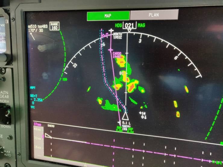
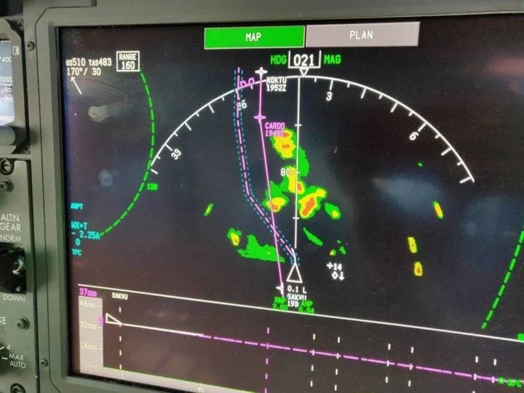
As a result, particularly dense water droplets such as hailstones will have a greater return than less dense droplets such as fog. Still with me? These returns are then depicted in the flight deck on the navigation display. Green areas are those of low returns, whilst red indicates areas of high returns.
Most weather radar systems on newer aircraft also feature a turbulence detection function. This uses the Doppler effect to detect the movement of the water droplets and areas of turbulence are depicted on the screen in magenta.
Because this still requires the presence of moisture, it is really only useful at predicting turbulence around thunderstorms and not clear air turbulence caused by shifts in the wind.
How pilots use radar
How pilots control the weather radar system depends on the aircraft type. On the Boeing 787 Dreamliner, each pilot has his or her own controls to operate the radar system.
For the most part, after we have switched it on, we leave it in automatic mode. This allows the system to sweep the area ahead of the aircraft, enabling it to build up as accurate a picture as possible.
Should we want to refine this, we are able to adjust the gain (how sensitive the system is) and also the tilt (how far down the outbound beam is). On older aircraft, it could be difficult to determine which returns were clouds and which were mountains. By fine-tuning the gain and the tilt, we were able to create a more accurate picture.
However, the automatic feature on most modern aircraft is so good that we rarely take it out of automatic mode.
Limitations of the system
As great as the advances in technology have made modern systems, there are still limitations as to what they can do. As mentioned, radar systems are only able to detect the presence of moisture.
This is fine lower down in a thunderstorm cloud where there is a high concentration of water vapor. But, higher up in the cloud, there is considerably less vapor.
With a good knowledge of meteorology, a pilot will know that the threat of thunderstorms doesn't just come from the water vapor in the form of heavy rain and hail, but also from the incredibly strong convective currents that circulate within these clouds.
As a result, even if an area at the top of a thunderstorm is showing a green return, as an area of very little moisture, the convective currents could still cause severe turbulence. This is particularly true over land in areas around the equator, a region known as the Intertropical Convergence Zone.
Here, colliding air masses create a significant uplift of air and generate thunderstorms that can be over 50,000 feet high — well above the height airliners can cruise. Conversely, the air close to the sea can be very humid, creating clouds that are full of water but not necessarily a serious threat to the aircraft.
Another limitation of the system is known as beam attenuation. This happens when the radar beam hits an area of weather where the precipitation is so dense that the reflection is unable to make it back to the aircraft, resulting in a blank area on the pilots' screen.
To the untrained eye this may look like there is no weather at all, even though the opposite is true. This attenuation stops the true intensity of the weather being displayed on the screen and it may also hide another thunderstorm on the other side of the first one. As a result, pilots learn how to spot signs of beam attenuation and act accordingly.
The future of weather radar
Despite the quality of modern weather radar systems, manufacturers are always looking for ways to improve the technology to make flying even safer.
At cruising altitudes, for example, ice crystals are all but invisible. The first signs of encountering these ice crystals are often when the pilots see what appears to be rain on the windshield, as the ice crystals melt on the heated screen. Whilst they will not cause the wing surfaces to ice up, they can affect the engines.
The FAA has conducted various studies and found that, since 1989, ice crystals have caused around 150 flights issues. These have ranged from fan blade damage and loss of engine power to engine stalls and complete engine failures.
As a result, manufacturers are focusing their efforts on improving weather radar systems so that they can detect areas of high-altitude ice crystals and display them to the pilots.
Bottom line
The weather radar system on modern aircraft help pilots keep passengers safe and the ride smooth by displaying the location and severity of storms. With this picture and their theoretical knowledge of these weather systems, pilots are then able to plot a course safely around the worst of the weather.
Sometimes, this might involve going off course by hundreds of miles, so even if you're looking out an aircraft window and see lightning, there's a good chance the flight is still nice and smooth because the pilots have used weather radar to keep you out of the storms and in the clear.
TPG featured card
at Capital One's secure site
Terms & restrictions apply. See rates & fees.
| 5X miles | Earn 5X miles on hotels, vacation rentals and rental cars booked through Capital One Travel |
| 2X miles | Earn unlimited 2X miles on every purchase, every day |
Pros
- Stellar welcome offer of 75,000 miles after spending $4,000 on purchases in the first three months from account opening. Plus, a $250 Capital One Travel credit to use in your first cardholder year upon account opening.
- You'll earn 2 miles per dollar on every purchase, which means you won't have to worry about memorizing bonus categories
- Rewards are versatile and can be redeemed for a statement credit or transferred to Capital One’s transfer partners
Cons
- Highest bonus-earning categories only on travel booked via Capital One Travel
- LIMITED-TIME OFFER: Enjoy $250 to use on Capital One Travel in your first cardholder year, plus earn 75,000 bonus miles once you spend $4,000 on purchases within the first 3 months from account opening - that’s equal to $1,000 in travel
- Earn unlimited 2X miles on every purchase, every day
- Earn 5X miles on hotels, vacation rentals and rental cars booked through Capital One Travel
- Miles won't expire for the life of the account and there's no limit to how many you can earn
- Receive up to a $120 credit for Global Entry or TSA PreCheck®
- Use your miles to get reimbursed for any travel purchase—or redeem by booking a trip through Capital One Travel
- Enjoy a $50 experience credit and other premium benefits with every hotel and vacation rental booked from the Lifestyle Collection
- Transfer your miles to your choice of 15+ travel loyalty programs
- Top rated mobile app


